1930s Maps of Madison, Alabama
Explore 5 historic maps of Madison from the 1930s. These maps offer a rare glimpse into what life looked like during the 1930s — showing old roads, neighborhoods, homes, and landmarks that have changed or disappeared over time.
Whether you're researching your family's past, planning a metal detecting trip, or studying how Madison's landscape evolved across the 1930s, these high-resolution maps are a powerful tool for exploring the history of this region.
- Focus on a specific era: All maps on this page are from the 1930s, giving you a focused view of this time period.
- See what’s changed: Compare century-old streets, trails, and buildings to today's modern landscape using overlays and satellite layers.
- Research with precision: Use these maps for genealogy, historical research, land use analysis, or educational projects.
- View, download, or print: Maps are fully viewable online in high resolution, and can be downloaded or printed for your own records.
Start exploring Madison's history through authentic maps from the 1930s. This is your window into the past.
Madison, AL maps
(5)- 1936 Map of Jeff
 1936 Jeff1936 Print · USGSMadison County rural life is captured in the mid-1930s, showing a landscape defined by ancestral lines and small-town centers. Trace family roots through Indian Creek Cem, St John Cem, and old schools like Little Indian Creek Sch.
 - 1936 Map of Capshaw
 1936 Capshaw1936 Print · USGSLimestone and Madison counties are captured here in the mid-1930s as the Tennessee Valley Authority and Alabama Power began modernizing the rural landscape. Researchers can locate numerous vanished country schools like Grimett Sch, family landmarks such as McCully Mill, and the community at Wesley Chapel.
 - 1936 Map of Madison
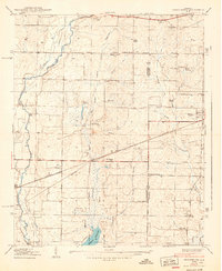
 1936 Madison1936 Print · USGSMadison and its surrounding farmstead landscape are captured in the mid-1930s just as the Tennessee Valley Authority began transforming the river valley. Researchers can locate numerous vanished landmarks like Lankford Mill, trace the CHICKASAW BOUNDARY, and find family sites near Brandontown or Fuller Chapel.
 - 1936 Map of Greenbrier
 1936 Greenbrier1936 Print · USGSAlabama's Tennessee Valley was undergoing a massive transformation in the mid-1930s as the river was harnessed for power. Genealogists can locate family-named settlements like Peete Corners, small rural schools like Betz Sch, and old spiritual centers like Fletcher Chapel.
 - 1938 Map of Greenbrier
 1938 Greenbrier1938 Print · USGSLimestone and Madison Counties are shown in the late 1930s as a landscape of rural schoolhouses and family cemeteries. Genealogists can trace local heritage through sites like Ragland Cem, Mt Pleasant Sch, and the crossroads at Burgreen Corner.3 unique versions available
End of results
Showing maps 1-5 of 5
Top cities near Madison
- Huntsville historical maps
- Decatur historical maps
- Athens historical maps
- Hartselle historical maps
- Meridianville historical maps
- Harvest historical maps
See more
Top neighborhoods of Madison
- Rainbow historical maps
- Oakland historical maps
- Rainbow Gap Estates historical maps
- Maplewood historical maps
- Brentwood historical maps
- Clift Acres historical maps
See more
Frequently asked questions
- What are the different types of historical maps available for Madison?
- What is the oldest map of Madison?
- Where can I purchase historical maps of Madison for my home or office?
- Where can I download high-res historical maps of Madison?
- Are there historical topographic maps available for Madison?
- Is there historical aerial imagery available for Madison?
- Where are historical maps of Madison sourced from?