1980s Maps of Marengo County, Alabama
Explore 7 historic maps of Marengo County from the 1980s. These maps offer a rare glimpse into what life looked like during the 1980s — showing old roads, neighborhoods, homes, and landmarks that have changed or disappeared over time.
Whether you're researching your family's past, planning a metal detecting trip, or studying how Marengo County's landscape evolved across the 1980s, these high-resolution maps are a powerful tool for exploring the history of this region.
- Focus on a specific era: All maps on this page are from the 1980s, giving you a focused view of this time period.
- See what’s changed: Compare century-old streets, trails, and buildings to today's modern landscape using overlays and satellite layers.
- Research with precision: Use these maps for genealogy, historical research, land use analysis, or educational projects.
- View, download, or print: Maps are fully viewable online in high resolution, and can be downloaded or printed for your own records.
Start exploring Marengo County's history through authentic maps from the 1980s. This is your window into the past.
Marengo County, AL maps
(7)- 1980 Map of Casemore
 1980 Casemore1980 Print · USGSHale County's fertile Black Belt region is captured here in the 1980s, defined by the winding Black Warrior River and a dense network of rural communities. Researchers can trace local heritage through numerous landmarks like St Andrews Ch, Lock 5, and the old settlement of Prairieville.4 unique versions available
 - 1984 Map of Hattiesburg
 1984 Hattiesburg1984 Print · USGSSouth Mississippi’s Pine Belt is seen here in the mid-eighties, showing the region as a hub of timber production and petroleum extraction. Trace the rail lines of the Illinois Central Gulf RR through old settlements like Richton or the energy developments at the Heidelberg Oil Field.2 unique versions available
 - 1984 Map of Waynesboro
 1984 Waynesboro1984 Print · USGSThe borderlands of Mississippi and Alabama come alive in this mid-eighties survey of timber and river country. Researchers can trace the Illinois Central Gulf Railroad corridor through Waynesboro and Shubuta, or locate remote lookouts like Maynor Creek Lookout.2 unique versions available
 - 1984 Map of Meridian
 1984 Meridian1984 Print · USGSEastern Mississippi and Western Alabama come alive in the mid-1980s, showing the expansion of Meridian and the surrounding timber and river lands. Genealogists and researchers can trace family landmarks like Memorial Park Cem, the Pine Springs church, and the rural roads near Kewanee.3 unique versions available
 - 1986 Map of Selma
 1986 Selma1986 Print · USGSCentral Alabama's river and rail networks are preserved here in the mid-eighties, showing the transition from river travel to modern infrastructure. Researchers can trace the layout of Selma, the historic capital at Cahaba, and the Millers Ferry Lock and Dam.2 unique versions available
 - 1986 Map of Monroeville
 1986 Monroeville1986 Print · USGSMonroe and Clarke counties are captured here in the mid-eighties, centered on the river valleys of the Alabama River and Tombigbee River. Genealogists and local historians can trace legacy settlements like Burnt Corn, Whatley, and the river site of Claiborne.2 unique versions available
 - 1986 Map of Demopolis
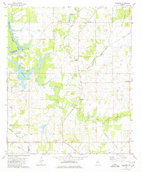
 1986 Demopolis1986 Print · USGSWest-central Alabama's river-and-rail corridors are preserved here in the mid-eighties, showing the deep-seated settlement patterns of the Black Belt. Genealogists and historians can locate family-named landmarks like Crenshaw Quarters or industrial sites including Cleveland Mills and the Warrior Lock and Dam.
End of results
Showing maps 1-7 of 7
Top cities of Marengo County
- Demopolis historical maps
- Linden historical maps
- Thomaston historical maps
- Sweet Water historical maps
- Providence historical maps
- Faunsdale historical maps
See more
Frequently asked questions
- What are the different types of historical maps available for Marengo County?
- What is the oldest map of Marengo County?
- Where can I purchase historical maps of Marengo County for my home or office?
- Where can I download high-res historical maps of Marengo County?
- Are there historical topographic maps available for Marengo County?
- Is there historical aerial imagery available for Marengo County?
- Where are historical maps of Marengo County sourced from?