1950s Maps of Grant, Alabama
Explore 5 historic maps of Grant from the 1950s. These maps offer a rare glimpse into what life looked like during the 1950s — showing old roads, neighborhoods, homes, and landmarks that have changed or disappeared over time.
Whether you're researching your family's past, planning a metal detecting trip, or studying how Grant's landscape evolved across the 1950s, these high-resolution maps are a powerful tool for exploring the history of this region.
- Focus on a specific era: All maps on this page are from the 1950s, giving you a focused view of this time period.
- See what’s changed: Compare century-old streets, trails, and buildings to today's modern landscape using overlays and satellite layers.
- Research with precision: Use these maps for genealogy, historical research, land use analysis, or educational projects.
- View, download, or print: Maps are fully viewable online in high resolution, and can be downloaded or printed for your own records.
Start exploring Grant's history through authentic maps from the 1950s. This is your window into the past.
Grant, AL maps
(5)- 1950 Map of Swearengin
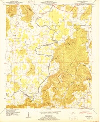
 1950 Swearengin1950 Print · USGSNortheast Alabama hill country meets the Tennessee River in the late 1940s, showing a landscape defined by mountain coves and the backwaters of the reservoir. Researchers can locate family landmarks like Zions Rest Cem, New Prospect School, and the scattered homes of Swearengin.2 unique versions available
 - 1950 Map of Mt Carmel
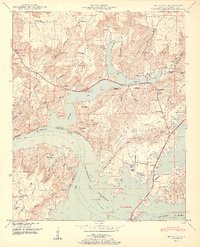 1950 Mt Carmel1950 Print · USGSIn the decade following the reservoir's creation, this Marshall County landscape shows a mix of riverside settlements and steep mountain ridges. Genealogists and researchers can locate family sites like Henryville, Manchester, and Baker Chapel, or trace the old N C & St L Ry Ferry route.2 unique versions available
 - 1950 Map of Grant
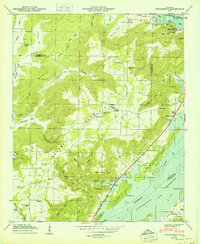
 1950 Grant1950 Print · USGSNortheast Alabama at mid-century shows a landscape of river-valley farms and steep ridges at the intersection of three counties. Trace old river crossings at Helium Ford and Fishtrap Ford, or locate family landmarks like Poplar Ridge, Butler Mill, and the D A R Sch.2 unique versions available
 - 1956 Map of Gadsden, 1966 Print
 1956 Gadsden1966 Print · USGSNorth Alabama in the mid-1950s shows a region transformed by river engineering and federal industry. Genealogists and local historians can trace the development of the Tennessee Valley through the growth of Huntsville, the sprawling Redstone Arsenal, and the expansive Guntersville Lake.3 unique versions available
 - 1958 Map of Gadsden
 1958 Gadsden1958 Print · USGSNorth Alabama comes alive in the late 1950s as the Tennessee Valley Authority’s massive river projects and the rise of the space industry reshaped the landscape. Researchers can trace the mid-century footprints of Huntsville, Redstone Arsenal, and the riverside rail networks of the Southern railroad.
End of results
Showing maps 1-5 of 5
Top cities near Grant
- Huntsville historical maps
- Albertville historical maps
- Scottsboro historical maps
- Guntersville historical maps
- Arab historical maps
- New Hope historical maps
See more
Frequently asked questions
- What are the different types of historical maps available for Grant?
- What is the oldest map of Grant?
- Where can I purchase historical maps of Grant for my home or office?
- Where can I download high-res historical maps of Grant?
- Are there historical topographic maps available for Grant?
- Is there historical aerial imagery available for Grant?
- Where are historical maps of Grant sourced from?