1950s Maps of Bayou La Batre, Alabama
Explore 5 historic maps of Bayou La Batre from the 1950s. These maps offer a rare glimpse into what life looked like during the 1950s — showing old roads, neighborhoods, homes, and landmarks that have changed or disappeared over time.
Whether you're researching your family's past, planning a metal detecting trip, or studying how Bayou La Batre's landscape evolved across the 1950s, these high-resolution maps are a powerful tool for exploring the history of this region.
- Focus on a specific era: All maps on this page are from the 1950s, giving you a focused view of this time period.
- See what’s changed: Compare century-old streets, trails, and buildings to today's modern landscape using overlays and satellite layers.
- Research with precision: Use these maps for genealogy, historical research, land use analysis, or educational projects.
- View, download, or print: Maps are fully viewable online in high resolution, and can be downloaded or printed for your own records.
Start exploring Bayou La Batre's history through authentic maps from the 1950s. This is your window into the past.
Bayou La Batre, AL maps
(5)- 1953 Map of Mobile, 1968 Print
 1953 Mobile1968 Print · USGSThe Gulf Coast comes alive in this mid-century survey, from the streets of Mobile to the marshes of New Orleans. Trace family roots in coastal towns like Pass Christian and Bayou La Batre or locate military landmarks including Keesler AFB.3 unique versions available
 - 1956 Map of Coden, 1957 Print
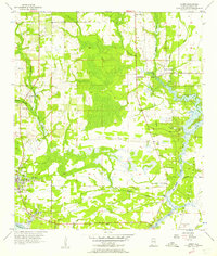 1956 Coden1957 Print · USGSThe Alabama coast in the mid-1950s is captured here, from the bustling waterfront of Bayou La Batre to the famous Bellingrath Gardens. Researchers can trace old family sites and transport routes through Coden, St Pauls Ch, and an Old Railroad Grade.3 unique versions available
 - 1957 Map of Mobile
 1957 Mobile1957 Print · USGSThe Gulf Coast in the mid-1950s reveals a bustling corridor of rail-and-river commerce connecting Alabama to Louisiana. Genealogists and historians can trace old settlements and military hubs from Keesler Afb to the coastal reaches of Ship Island and Bogalusa.3 unique versions available
 - 1958 Map of Grand Bay, 1959 Print
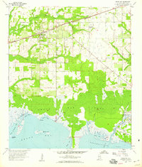 1958 Grand Bay1959 Print · USGSCoastal Mobile County is shown here in the late fifties, where the railroad and the Gulf shoreline shaped local life. Genealogists and historians can trace the inland settlement of Grand Bay, the St Elmo Landing Field, and the fishing waters of Bayou La Batre.3 unique versions available
 - 1958 Map of Grand Bay, 1959 Print
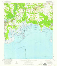 1958 Grand Bay1959 Print · USGSThe coastal borderlands of Alabama and Mississippi come alive in the late fifties, where rail and river networks meet the Gulf. Genealogists and local historians can trace family-named sites like Dees Cem and Kivisto Cem or explore the working waterfronts of Bayou La Batre and Moss Point.2 unique versions available
End of results
Showing maps 1-5 of 5
Top cities near Bayou La Batre
- Mobile historical maps
- Tillmans Corner historical maps
- Moss Point historical maps
- Theodore historical maps
- Grand Bay historical maps
- Dauphin Island historical maps
See more
Frequently asked questions
- What are the different types of historical maps available for Bayou La Batre?
- What is the oldest map of Bayou La Batre?
- Where can I purchase historical maps of Bayou La Batre for my home or office?
- Where can I download high-res historical maps of Bayou La Batre?
- Are there historical topographic maps available for Bayou La Batre?
- Is there historical aerial imagery available for Bayou La Batre?
- Where are historical maps of Bayou La Batre sourced from?