1970s Maps of Oxford, Alabama
Explore 3 historic maps of Oxford from the 1970s. These maps offer a rare glimpse into what life looked like during the 1970s — showing old roads, neighborhoods, homes, and landmarks that have changed or disappeared over time.
Whether you're researching your family's past, planning a metal detecting trip, or studying how Oxford's landscape evolved across the 1970s, these high-resolution maps are a powerful tool for exploring the history of this region.
- Focus on a specific era: All maps on this page are from the 1970s, giving you a focused view of this time period.
- See what’s changed: Compare century-old streets, trails, and buildings to today's modern landscape using overlays and satellite layers.
- Research with precision: Use these maps for genealogy, historical research, land use analysis, or educational projects.
- View, download, or print: Maps are fully viewable online in high resolution, and can be downloaded or printed for your own records.
Start exploring Oxford's history through authentic maps from the 1970s. This is your window into the past.
Oxford, AL maps
(3)- 1975 Map of Oxford, 1977 Print
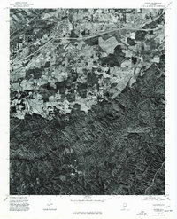 1975 Oxford1977 Print · USGSCalhoun County's transition from city to forest is captured in the mid-seventies just as the corridor between Anniston and Trinity was expanding. Genealogists and historians can trace the precise 1975 land use and the path of Choccolocco Creek.
 - 1975 Map of Choccolocco, 1977 Print
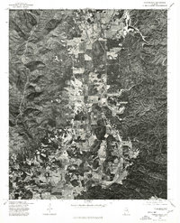 1975 Choccolocco1977 Print · USGSCalhoun County comes into focus in the mid-1970s through this aerial orthophotoquad of the valley landscape. Researchers can trace the exact footprint of farmsteads and homes near Choccolocco, Iron City, and the winding Choccolocco Creek.
 - 1975 Map of Hollis Crossroads, 1977 Print
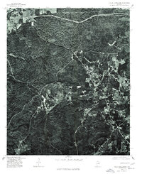 1975 Hollis Crossroads1977 Print · USGSHollis Crossroads and the timbered hills of Cleburne County appear as they were in the mid-seventies in this detailed orthophotograph. Genealogists and local historians can trace the rural road networks and land clearings around Five Points, Hollis Crossroads, and Lake Edmond.
End of results
Showing maps 1-3 of 3
Top cities near Oxford
- Anniston historical maps
- Talladega historical maps
- Jacksonville historical maps
- Saks historical maps
- Lincoln historical maps
- Weaver historical maps
See more
Top neighborhoods of Oxford
- DeArmanville historical maps
- Oak Hill historical maps
- McKibben historical maps
- Gauldinville historical maps
- New Haven historical maps
- Bynum historical maps
See more
Frequently asked questions
- What are the different types of historical maps available for Oxford?
- What is the oldest map of Oxford?
- Where can I purchase historical maps of Oxford for my home or office?
- Where can I download high-res historical maps of Oxford?
- Are there historical topographic maps available for Oxford?
- Is there historical aerial imagery available for Oxford?
- Where are historical maps of Oxford sourced from?