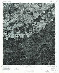
1975 Map of Oxford
USGS Topo · Published 1977About this map
Anniston and the community of Trinity anchor the northwestern portion of this mid-1970s orthophotoquad, which captures the transition between expanding urban development and the dense, ridged forest land of eastern Alabama. Produced by the Geological Survey in cooperation with the Soil Conservation Service, this map uses aerial photography from December 1975 to document the landscape with photographic precision. The winding course of Choccolocco Creek carves through the central valley, providing a clear visual contrast between the agricultural clearings of the lowlands and the dark, textured canopy of the surrounding hills. This specific edition is particularly useful for researchers studying the intersection of transportation infrastructure and natural topography, as it preserves the exact footprint of early-seventies residential and industrial growth before later decades of further expansion altered these valley corridors.
Find a feature on this map
3 named features on this map. Tap any name to fly to it.
Don’t see what you’re looking for? This feature index may not catch every label — zoom into the map to look around manually.
Map Details
Editions of this 1975 Oxford Map
This is the sole edition of this map. No revisions or reprints were ever made.
Other maps of this area

1891 · Ashland
USGS Topo · 1:125,000

1900 · Anniston
USGS Topo · 1:125,000

1947 · Oxford
USGS Topo · 1:24,000

1947 · Anniston
USGS Topo · 1:24,000

1947 · Eulaton
USGS Topo · 1:24,000

1947 · Munford
USGS Topo · 1:24,000

1950 · Anniston
USGS Topo · 1:62,500

1953 · Atlanta
USGS Topo · 1:250,000

1954 · Choccolocco
USGS Topo · 1:24,000

1956 · Munford
USGS Topo · 1:24,000