1960s Maps of Troy, Alabama
Explore 6 historic maps of Troy from the 1960s. These maps offer a rare glimpse into what life looked like during the 1960s — showing old roads, neighborhoods, homes, and landmarks that have changed or disappeared over time.
Whether you're researching your family's past, planning a metal detecting trip, or studying how Troy's landscape evolved across the 1960s, these high-resolution maps are a powerful tool for exploring the history of this region.
- Focus on a specific era: All maps on this page are from the 1960s, giving you a focused view of this time period.
- See what’s changed: Compare century-old streets, trails, and buildings to today's modern landscape using overlays and satellite layers.
- Research with precision: Use these maps for genealogy, historical research, land use analysis, or educational projects.
- View, download, or print: Maps are fully viewable online in high resolution, and can be downloaded or printed for your own records.
Start exploring Troy's history through authentic maps from the 1960s. This is your window into the past.
Troy, AL maps
(6)- 1960 Map of Brundidge NW, 1963 Print
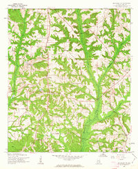 1960 Brundidge NW1963 Print · USGSPike County settlements and early 1960s industry meet in this detailed survey of the Alabama countryside. Genealogists can trace family roots through numerous local landmarks like Spring Hill Sch, Antioch Ch, and the rural community of Tarentum.2 unique versions available
 - 1962 Map of Brundidge NW
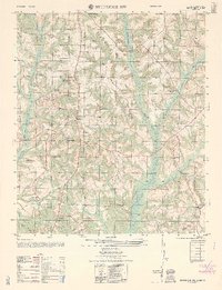 1962 Brundidge NW1962 Print · USGSLife in rural Pike County during the early sixties is detailed here through its network of country schools and churches. Genealogists can locate specific family landmarks like Springhill School, Tarentum, and the White Water Church (abandoned).
 - 1968 Map of Goshen, 1970 Print
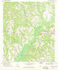
 1968 Goshen1970 Print · USGSGoshen and the Conecuh River valley are shown here in the late sixties as the local economy balanced traditional farming with emerging extractive industries. Genealogists can trace family names at Hillcrest Cem, Mt Hilliard Ch, and the crossroads at Little Oak.2 unique versions available
 - 1968 Map of Youngblood, 1970 Print
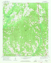
 1968 Youngblood1970 Print · USGSPike County in the late sixties reveals a landscape shaped by the Conecuh River and the intersecting routes of the Seaboard Coast Line. Researchers can locate several family-centric landmarks and rural congregations, from Hephzibah and Shellhorn to New Mt Zion Ch.2 unique versions available
 - 1968 Map of Ansley, 1971 Print
 1968 Ansley1971 Print · USGSThe Pike and Montgomery county line in the late 1960s was a landscape of remote farmsteads and creek-side settlements. Genealogists can locate family landmarks like Shellhorn, the Seaboard Coast railroad corridor at Ansley, and several rural burial sites such as Pine Grove Cem.2 unique versions available
 - 1968 Map of Troy, 1971 Print
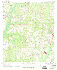
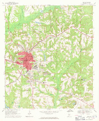 1968 Troy1971 Print · USGSPike County at the height of the 1960s shows a thriving regional center as Troy State Univ expands alongside established neighborhoods. Genealogists and historians can trace the foundations of the community through Oakwood Cem, the Seaboard Coast Line railroad, and McClure Town.2 unique versions available
End of results
Showing maps 1-6 of 6
Top cities near Troy
- Brundidge historical maps
- Ariton historical maps
- Goshen historical maps
- Banks historical maps
- Glenwood historical maps
Top neighborhoods of Troy
- Mountainbrook historical maps
- Northdale historical maps
- Allred historical maps
- Forest Circle historical maps
- Green Oaks historical maps
- Heritage Ridge historical maps
See more
Frequently asked questions
- What are the different types of historical maps available for Troy?
- What is the oldest map of Troy?
- Where can I purchase historical maps of Troy for my home or office?
- Where can I download high-res historical maps of Troy?
- Are there historical topographic maps available for Troy?
- Is there historical aerial imagery available for Troy?
- Where are historical maps of Troy sourced from?