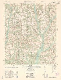
1962 Map of Brundidge NW
USGS Topo · Published 1962About this map
The agrarian and early industrial landscape of Pike County comes into focus through this survey, centered on the communities of Springhill and Tarentum. Small country congregations and local education hubs serve as the primary landmarks, including the Springhill School, Elam Church, and Union Springs Church. The presence of several Strip mine (abandoned) sites and a Borrow pit (abandoned) suggests a period of transition as local resource extraction gave way to other uses.
Find a feature on this map
28 named features on this map. Tap any name to fly to it.
Don’t see what you’re looking for? This feature index may not catch every label — zoom into the map to look around manually.
Map Details
Editions of this 1962 Brundidge NW Map
This is the sole edition of this map. No revisions or reprints were ever made.
Other maps of this area

1948 · Brundidge
USGS Topo · 1:62,500

1950 · Brundidge
USGS Topo · 1:62,500

1953 · Andalusia
USGS Topo · 1:250,000

1953 · Dothan
USGS Topo · 1:250,000

1954 · Dothan
USGS Topo · 1:250,000

1955 · Dothan
USGS Topo · 1:250,000

1957 · Andalusia
USGS Topo · 1:250,000

1960 · Brundidge
USGS Topo · 1:24,000

1960 · Brundidge SE
USGS Topo · 1:24,000

1960 · Victoria
USGS Topo · 1:24,000