1940s Maps of St. Clair County, Alabama
Explore 11 historic maps of St. Clair County from the 1940s. These maps offer a rare glimpse into what life looked like during the 1940s — showing old roads, neighborhoods, homes, and landmarks that have changed or disappeared over time.
Whether you're researching your family's past, planning a metal detecting trip, or studying how St. Clair County's landscape evolved across the 1940s, these high-resolution maps are a powerful tool for exploring the history of this region.
- Focus on a specific era: All maps on this page are from the 1940s, giving you a focused view of this time period.
- See what’s changed: Compare century-old streets, trails, and buildings to today's modern landscape using overlays and satellite layers.
- Research with precision: Use these maps for genealogy, historical research, land use analysis, or educational projects.
- View, download, or print: Maps are fully viewable online in high resolution, and can be downloaded or printed for your own records.
Start exploring St. Clair County's history through authentic maps from the 1940s. This is your window into the past.
St. Clair County, AL maps
(11)- 1943 Map of Talladega, 1972 Print
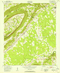
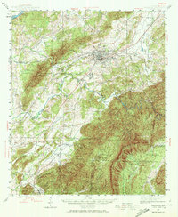 1943 Talladega1972 Print · USGSTalladega and its mountain ridges are captured here during the early years of the Second World War, showing a landscape defined by rail and rural industry. Researchers can trace family roots through numerous country landmarks like Reynolds Mill, the County Training School, and Winterboro.2 unique versions available
 - 1946 Map of Talladega
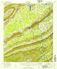
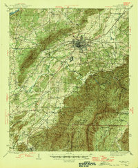 1946 Talladega1946 Print · USGSTalladega and its surrounding hill country are captured here in the mid-1940s as a vital railroad and milling crossroads. Genealogists can locate family landmarks like Allison Mills, Antioch Ch, and the Mardisville Sch among the rural settlements.2 unique versions available
 - 1947 Map of Cox Gap, 1948 Print
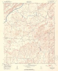
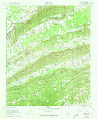 1947 Cox Gap1948 Print · USGSSt. Clair County's ridge-and-valley landscape is captured here in the years following World War II, when rural life centered on small mountain gaps and creek-side churches. Genealogists can locate family landmarks like Bethany Ch, Ashville, and the remote Gum Springs Ch.5 unique versions available
 - 1947 Map of Dunaway Mountain, 1953 Print
 1947 Dunaway Mountain1953 Print · USGSThe Etowah County countryside near Gadsden is captured here just after World War II, showing a landscape transitioning from military use to civil expansion. Researchers can trace the grounds of Camp Sibert (Abandoned) or locate local landmarks like Listers Ferry (Abandoned) and Old Harmony Ch.3 unique versions available
 - 1947 Map of Ragland, 1953 Print
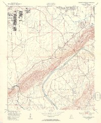
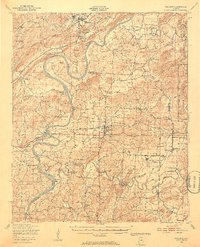 1947 Ragland1953 Print · USGSIn the late 1940s, the Coosa River valley was a landscape of deep-rooted rural communities and growing military installations. Genealogists can trace family landmarks like Rhodes Chapel and old mills such as Martins Mill or Francis Mill.3 unique versions available
 - 1947 Map of Ragland, 1953 Print
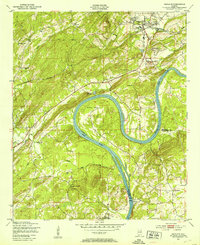 1947 Ragland1953 Print · USGSPost-war St. Clair County comes to life as the Coosa River winds through Emory Bend. Genealogists and historians can trace community roots at Rhodes Chapel, Robinson Sch, and the industrial sidings of the Seaboard Air Line in Ragland.4 unique versions available
 - 1947 Map of Riverside, 1953 Print
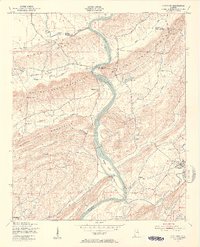
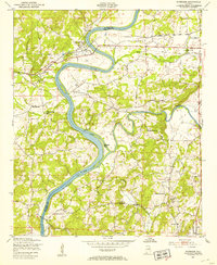 1947 Riverside1953 Print · USGSRiverside and the riverbanks of St. Clair and Talladega counties appear here just after the war, when the railroad and river still dictated the local economy. Genealogists can locate family landmarks like Seddon Cem, Idelia Sch, and the riverside Lock No 5 (Abandoned).4 unique versions available
 - 1947 Map of Francis Mill, 1953 Print
 1947 Francis Mill1953 Print · USGSCalhoun and Talladega counties appear just after the war, showing a landscape transitioning between traditional milling and major military installations. Researchers can locate family landmarks like Bailey Springs Sch, Refuge Ch, and the site of Francis Mill.4 unique versions available
 - 1947 Map of Steele, 1953 Print
 1947 Steele1953 Print · USGSNorthern St. Clair County appears here in the immediate post-war years as military installations give way to rural life. Researchers can trace the boundaries of Camp Sibert, find old family church sites like Deerman Chapel, and follow the Southern rail line through Steele.3 unique versions available
 - 1947 Map of Steele, 1953 Print
 1947 Steele1953 Print · USGSMid-century Alabama life centered on the river and rail corridors between Gadsden and Ashville. Genealogists can locate family landmarks like Morgans Crossroad, Old Harmony Ch Cem, and the decommissioned Camp Sibert.2 unique versions available
 - 1949 Map of Ohatchee, 1953 Print
 1949 Ohatchee1953 Print · USGSThe Coosa River valley in the late 1940s shows a landscape of steep ridges and tight-knit river settlements along the Calhoun and St. Clair county lines. Local historians can trace the paths of the Seaboard Air Line and find sites like Francis Ferry, Greensport, and Ten Island Ch.5 unique versions available
End of results
Showing maps 1-11 of 11
Top cities of St. Clair County
- Moody historical maps
- Pell City historical maps
- Margaret historical maps
- Odenville historical maps
- Springville historical maps
- Argo historical maps
See more
Frequently asked questions
- What are the different types of historical maps available for St. Clair County?
- What is the oldest map of St. Clair County?
- Where can I purchase historical maps of St. Clair County for my home or office?
- Where can I download high-res historical maps of St. Clair County?
- Are there historical topographic maps available for St. Clair County?
- Is there historical aerial imagery available for St. Clair County?
- Where are historical maps of St. Clair County sourced from?