1970s Maps of St. Clair County, Alabama
Explore 20 historic maps of St. Clair County from the 1970s. These maps offer a rare glimpse into what life looked like during the 1970s — showing old roads, neighborhoods, homes, and landmarks that have changed or disappeared over time.
Whether you're researching your family's past, planning a metal detecting trip, or studying how St. Clair County's landscape evolved across the 1970s, these high-resolution maps are a powerful tool for exploring the history of this region.
- Focus on a specific era: All maps on this page are from the 1970s, giving you a focused view of this time period.
- See what’s changed: Compare century-old streets, trails, and buildings to today's modern landscape using overlays and satellite layers.
- Research with precision: Use these maps for genealogy, historical research, land use analysis, or educational projects.
- View, download, or print: Maps are fully viewable online in high resolution, and can be downloaded or printed for your own records.
Start exploring St. Clair County's history through authentic maps from the 1970s. This is your window into the past.
St. Clair County, AL maps
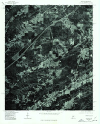
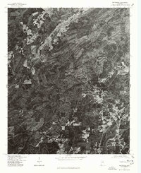
(20)- 1975 Map of Laniers, 1976 Print
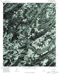
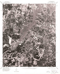 1975 Laniers1976 Print · USGSThe Alabama landscape near the Coosa River is captured in the mid-seventies just as the shoreline began to develop. Researchers can trace the winding branches of Logan Martin Lake and locate the small settlement of Laniers amidst the woods and fields.
 - 1975 Map of Vincent, 1977 Print
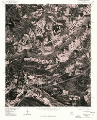
 1975 Vincent1977 Print · USGSShelby County in the mid-seventies is revealed through this detailed orthophoto survey, showing the town and its rural surroundings with photographic precision. Local historians can trace the clearings and road patterns around Vincent as they existed before modern expansion.
 - 1975 Map of Remlap, 1977 Print
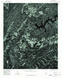 1975 Remlap1977 Print · USGSBlount County in the mid-seventies is captured in this detailed orthophoto, revealing the rural character of the Alabama landscape. Researchers can trace the sprawling reach of INLAND LAKE and find the small settlement of REMLAP along the western ridge.
 - 1975 Map of Ohatchee, 1977 Print
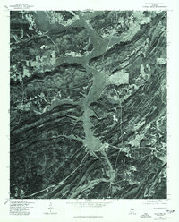 1975 Ohatchee1977 Print · USGSThe Coosa River valley in the mid-1970s reveals a landscape defined by its major reservoirs. Trace the shoreline of H Neely Henry Lake and the settlement of Ohatchee as they appeared just before the close of the decade.
 - 1975 Map of Ashville, 1977 Print
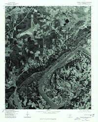
 1975 Ashville1977 Print · USGSSt. Clair County appears in sharp aerial detail during the mid-1970s, showing the intersection of new highway infrastructure and traditional valley life. Researchers can trace land divisions around Ashville or follow the riparian corridor of Big Canoe Creek past Whitney.
 - 1975 Map of Argo, 1977 Print
 1975 Argo1977 Print · USGSThe foothills of St. Clair County are shown during the mid-seventies in this detailed orthophotoquad. Researchers can trace the early footprint of the settlement at Argo and examine the rural land use patterns across the ridges and valleys of the Alabama landscape.
 - 1975 Map of Francis Mill, 1977 Print
 1975 Francis Mill1977 Print · USGSCalhoun County in the mid-1970s is shown here through detailed aerial imagery rather than standard line drawings. Trace rural property lines and land use patterns near the Coosa River and the small settlement of Francis Mill.
 - 1975 Map of Cooks Springs, 1977 Print
 1975 Cooks Springs1977 Print · USGSSt. Clair County appears in high-detail aerial imagery during the mid-seventies, showing the ridge-and-valley landscape of central Alabama. Genealogists and historians can pinpoint homesites and property boundaries near Cooks Springs, Moody, and Prescott.
 - 1975 Map of Steele, 1977 Print
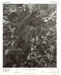
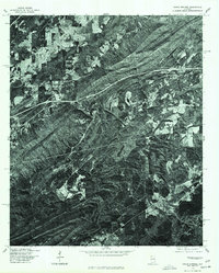
 1975 Steele1977 Print · USGSSt. Clair County settlements appear amidst the ridge-and-valley terrain during the mid-seventies. Researchers can examine the exact land use and road patterns surrounding Steele and Gallant as the interstate era reshaped the region.
 - 1975 Map of Dunaway Mountain, 1977 Print
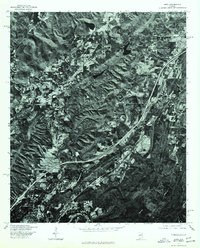
 1975 Dunaway Mountain1977 Print · USGSThe Coosa River valley comes into sharp focus during the mid-seventies, showing the transition from agricultural land to growing suburban centers. Local historians can trace the exact 1975 footprint of Rainbow City, the infrastructure of Gadsden, and the shoreline of H Neely Henry Lake.
 - 1975 Map of Riverside, 1977 Print
 1975 Riverside1977 Print · USGSIn the mid-seventies, the waters of Logan Martin Lake had recently transformed the St. Clair County landscape. Trace the shoreline development and transportation crossings near Riverside as they appeared just over a decade after the dam was completed.
 - 1975 Map of Ragland, 1977 Print
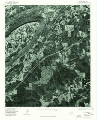
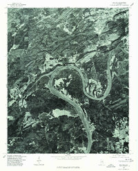 1975 Ragland1977 Print · USGSThe town of Ragland and the surrounding St. Clair County riverfront are shown in detail during the mid-seventies. Researchers can trace the exact shoreline of Logan Martin Lake and the winding path of the Coosa River from actual aerial photography.
 - 1975 Map of Talladega NW, 1977 Print
 1975 Talladega NW1977 Print · USGSMid-1970s Alabama comes into focus in this aerial survey, capturing the industrial and riverine character of the Talladega area. Local researchers can trace the development of Bemiston and examine the banks of the Coosa River at this moment in time.
 - 1975 Map of Hyatt Gap, 1977 Print
 1975 Hyatt Gap1977 Print · USGSIn the mid-seventies, the foothills of north-central Alabama are captured in stark detail through aerial photography. Researchers and landowners can trace field boundaries and mountain roads through the distinct terrain of Hyatt Gap as it appeared during this era.
 - 1975 Map of Cox Gap, 1977 Print
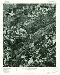
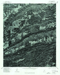 1975 Cox Gap1977 Print · USGSNear the town of Ashville in the mid-1970s, the rural Alabama landscape is defined by its dramatic ridges and agricultural clearings. Researchers can trace the path of the local Creek and examine field boundaries and early road networks across St. Clair County.
 - 1975 Map of Leeds, 1977 Print
 1975 Leeds1977 Print · USGSJefferson County during the mid-seventies shows a landscape of growing towns and industrial sites set against the sharp ridges of central Alabama. Trace the development of Leeds and Trussville through direct aerial imagery from this era.
 - 1975 Map of Pell City, 1977 Print
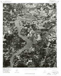
 1975 Pell City1977 Print · USGSPell City and the northern reaches of the Coosa River valley are captured in high-detail aerial imagery during the mid-seventies. Researchers can trace the development of the shoreline along Logan Martin Lake and the expanding footprint of Pell City.
 - 1975 Map of Wattsville, 1977 Print
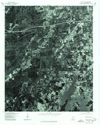
 1975 Wattsville1977 Print · USGSCovers St. Clair County, including Pell City, Odenville, and other nearby areas
 - 1975 Map of Odenville, 1977 Print
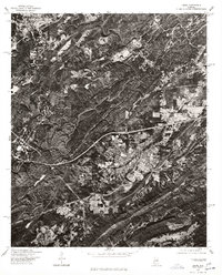
 1975 Odenville1977 Print · USGSOdenville and the surrounding St. Clair County landscape appear in crisp detail in this mid-seventies aerial survey. Researchers can trace the development of the road network and see the exact layout of land holdings around Odenville during this era.
 - 1975 Map of Springville, 1977 Print
 1975 Springville1977 Print · USGSSt. Clair County appears in high-contrast detail during the mid-seventies, showing the intersection of ridge-and-valley terrain with new infrastructure. Researchers can locate the historic community of Saint Clair Springs and trace the shoreline of INLAND LAKE.
End of results
Showing maps 1-20 of 20
Top cities of St. Clair County
- Moody historical maps
- Pell City historical maps
- Margaret historical maps
- Odenville historical maps
- Springville historical maps
- Argo historical maps
See more
Frequently asked questions
- What are the different types of historical maps available for St. Clair County?
- What is the oldest map of St. Clair County?
- Where can I purchase historical maps of St. Clair County for my home or office?
- Where can I download high-res historical maps of St. Clair County?
- Are there historical topographic maps available for St. Clair County?
- Is there historical aerial imagery available for St. Clair County?
- Where are historical maps of St. Clair County sourced from?