1960s Maps of St. Clair County, Alabama
Explore 2 historic maps of St. Clair County from the 1960s. These maps offer a rare glimpse into what life looked like during the 1960s — showing old roads, neighborhoods, homes, and landmarks that have changed or disappeared over time.
Whether you're researching your family's past, planning a metal detecting trip, or studying how St. Clair County's landscape evolved across the 1960s, these high-resolution maps are a powerful tool for exploring the history of this region.
- Focus on a specific era: All maps on this page are from the 1960s, giving you a focused view of this time period.
- See what’s changed: Compare century-old streets, trails, and buildings to today's modern landscape using overlays and satellite layers.
- Research with precision: Use these maps for genealogy, historical research, land use analysis, or educational projects.
- View, download, or print: Maps are fully viewable online in high resolution, and can be downloaded or printed for your own records.
Start exploring St. Clair County's history through authentic maps from the 1960s. This is your window into the past.
St. Clair County, AL maps
(2)- 1960 Map of Remlap, 1963 Print
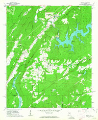 1960 Remlap1963 Print · USGSCentral Alabama's ridges and valleys are meticulously detailed in the early 1960s, showing the intersection of rural life and early industrial expansion. Trace family history at Pleasant Mount Ch or explore the geography of Remlap and Inland Reservoir.6 unique versions available
 - 1962 Map of Cooks Springs, 1964 Print
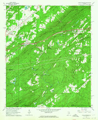 1962 Cooks Springs1964 Print · USGSSt. Clair County in the early sixties is a landscape of steep ridges and rail-side hamlets. Genealogists and local historians can trace family locations at Stewarts Crossroads, find rural landmarks like Taylors Ch, or follow the Southern Railway through Cooks Springs.4 unique versions available
End of results
Showing maps 1-2 of 2
Top cities of St. Clair County
- Moody historical maps
- Pell City historical maps
- Margaret historical maps
- Odenville historical maps
- Springville historical maps
- Argo historical maps
See more
Frequently asked questions
- What are the different types of historical maps available for St. Clair County?
- What is the oldest map of St. Clair County?
- Where can I purchase historical maps of St. Clair County for my home or office?
- Where can I download high-res historical maps of St. Clair County?
- Are there historical topographic maps available for St. Clair County?
- Is there historical aerial imagery available for St. Clair County?
- Where are historical maps of St. Clair County sourced from?