2000-2009 Maps of Sylacauga, Alabama
Explore 3 historic maps of Sylacauga from 2000-2009. These maps offer a rare glimpse into what life looked like during the 2000s — showing old roads, neighborhoods, homes, and landmarks that have changed or disappeared over time.
Whether you're researching your family's past, planning a metal detecting trip, or studying how Sylacauga's landscape evolved across the 2000s, these high-resolution maps are a powerful tool for exploring the history of this region.
- Focus on a specific era: All maps on this page are from the 2000s, giving you a focused view of this time period.
- See what’s changed: Compare century-old streets, trails, and buildings to today's modern landscape using overlays and satellite layers.
- Research with precision: Use these maps for genealogy, historical research, land use analysis, or educational projects.
- View, download, or print: Maps are fully viewable online in high resolution, and can be downloaded or printed for your own records.
Start exploring Sylacauga's history through authentic maps from the 2000s. This is your window into the past.
Sylacauga, AL maps
(3)- 2001 Map of Sylacauga East, 2004 Print
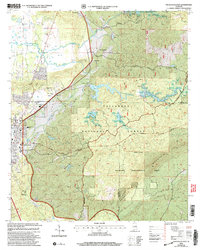 2001 Sylacauga East2004 Print · USGSTalladega County at the start of the millennium reveals a landscape shaped by the ridges of the National Forest and the winding path of Tallaseehatchee Creek. Local researchers can trace the settlement of Sycamore and the geography of Rebecca Mountain or Emawhee Creek.
 - 2001 Map of Winterboro, 2004 Print
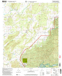 2001 Winterboro2004 Print · USGSTalladega County at the turn of the twenty-first century reveals a landscape shaped by the Talladega National Forest and historic creek-side settlements. Genealogists can locate family landmarks such as the Mt Olive Ch, Pittard Vocational Sch, and the community of Winterboro.
 - 2001 Map of Hollins, 2004 Print
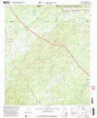 2001 Hollins2004 Print · USGSTalladega and Coosa counties met at the dawn of the millennium in this detailed study of the forest-heavy Alabama interior. Genealogists and local historians can trace rural community life through landmarks like Mt Pleasant Cem, Shiloh Ch, and the settlement of Hanover.
End of results
Showing maps 1-3 of 3
Top cities near Sylacauga
- Talladega historical maps
- Childersburg historical maps
- Vincent historical maps
- Wilsonville historical maps
- Westover historical maps
- Stewartville historical maps
See more
Top neighborhoods of Sylacauga
- Chico historical maps
- Lake Joy historical maps
- Walco historical maps
- Sunrise historical maps
- The Moon historical maps
Frequently asked questions
- What are the different types of historical maps available for Sylacauga?
- What is the oldest map of Sylacauga?
- Where can I purchase historical maps of Sylacauga for my home or office?
- Where can I download high-res historical maps of Sylacauga?
- Are there historical topographic maps available for Sylacauga?
- Is there historical aerial imagery available for Sylacauga?
- Where are historical maps of Sylacauga sourced from?