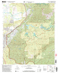
2001 Map of Sylacauga East
USGS Topo · Published 2004About this map
Sycamore serves as a primary settlement point in this Talladega County landscape, situated near the confluence of several significant water systems at the turn of the 21st century. The terrain is defined by the prominent ridge of Rebecca Mountain, which dominates the southeastern portion of the quadrangle. This area is heavily influenced by the drainage patterns of Tallaseehatchee Creek and Emawhee Creek, along with smaller tributaries like Foreman Branch, Crooked Creek, and Baker Br. The map reflects a region where the natural topography of the National Forest system dictates the placement of roads and human activity, offering a detailed look at the rural character of Alabama just after the late 1990s imagery revisions.
Find a feature on this map
7 named features on this map. Tap any name to fly to it.
Don’t see what you’re looking for? This feature index may not catch every label — zoom into the map to look around manually.
Map Details
Editions of this 2001 Sylacauga East Map
This is the sole edition of this map. No revisions or reprints were ever made.
Other maps of this area

1890 · Talladega
USGS Topo · 1:125,000

1892 · Talladega
USGS Topo · 1:125,000

1915 · Gantts Quarry
USGS Topo · 1:48,000

1917 · Gantts Quarry
USGS Topo · 1:62,500

1943 · Talladega
USGS Topo · 1:62,500

1944 · Goodwater
USGS Topo · 1:62,500

1946 · Talladega
USGS Topo · 1:62,500

1947 · Goodwater
USGS Topo · 1:62,500

1953 · Birmingham
USGS Topo · 1:250,000

1956 · Birmingham
USGS Topo · 1:250,000