Old Maps of Sylacauga, Alabama for Metal Detecting
Plan your next treasure hunt with 48 historic maps of Sylacauga. Find old homesites, ghost towns, trails, and gathering spots that may be lost to time — perfect for identifying promising metal detecting locations.
- Locate forgotten sites: Uncover places like long-lost settlements, abandoned rail lines, or gathering spots.
- Plan better hunts: Use map overlays combined with LiDAR or satellite views to narrow in on historically rich areas.
- Made for detectorists: Thousands of hobbyists use these maps to discover relics, coins, and hidden history.
Use these historic maps to boost your research and find new opportunities beneath the surface of Sylacauga.
Sylacauga, AL maps
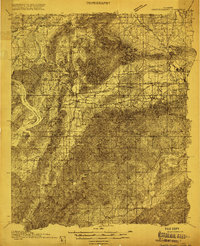
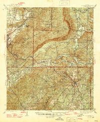
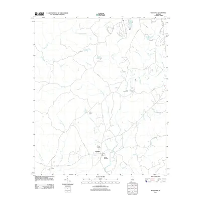
(48)- 1890 Map of Talladega
 1890 Talladega1890 Print · USGSTalladega and the surrounding river valleys are captured here in the late nineteenth century as the railroad and river economy flourished. Trace the locations of historic river crossings like Old Kymulga Ferry and local landmarks such as Odens Mill.
 - 1892 Map of Talladega
 1892 Talladega1892 Print · USGSTalladega County and the Coosa River valley are captured here in the late nineteenth century as the regional rail network expanded through the mountains. Researchers can locate old river crossings like Chancelors Ferry, rural landmarks such as Edwards Store, and early hubs like Childersburgh.6 unique versions available
 - 1915 Map of Gantts Quarry
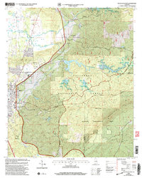
 1915 Gantts Quarry1915 Print · USGSTalladega and Shelby counties appear here during the height of the early twentieth-century marble boom. Researchers can trace the rail-driven economy near Sylacauga and locate family landmarks like Oak Grove Church, Gantts Quarry, and Center Hill School.4 unique versions available
 - 1917 Map of Gantts Quarry
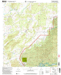
 1917 Gantts Quarry1917 Print · USGSThe marble-rich corridor between the Coosa River and Sylacauga is captured here during the height of the early twentieth-century quarrying boom. Researchers can trace the rail-and-river economy through landmarks like Gantts Quarry, Mc Gowan Ferry, and Eureka Quarry.3 unique versions available
 - 1943 Map of Talladega, 1972 Print
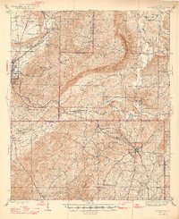
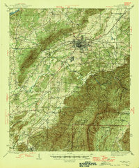
 1943 Talladega1972 Print · USGSTalladega and its mountain ridges are captured here during the early years of the Second World War, showing a landscape defined by rail and rural industry. Researchers can trace family roots through numerous country landmarks like Reynolds Mill, the County Training School, and Winterboro.2 unique versions available
 - 1944 Map of Goodwater, 1947 Print
 1944 Goodwater1947 Print · USGSThe hill country of Coosa and Talladega counties is captured here just after the war, showing the railroad-industrial corridor from Sylacauga to Goodwater. Genealogists and historians can trace numerous rural sites like Trammells Sch, Haynes Chapel, and the remote Hollins Fire Tower.3 unique versions available
 - 1946 Map of Talladega
 1946 Talladega1946 Print · USGSTalladega and its surrounding hill country are captured here in the mid-1940s as a vital railroad and milling crossroads. Genealogists can locate family landmarks like Allison Mills, Antioch Ch, and the Mardisville Sch among the rural settlements.2 unique versions available
 - 1947 Map of Goodwater
 1947 Goodwater1947 Print · USGSCoosa and Talladega counties in the mid-1940s are shown as a network of rail-side towns and ridge-top lookouts. Genealogists and historians can locate rural landmarks like Hatchet Springs Sch, the Hollins Fire Tower, and the historic Wiregrass Road.2 unique versions available
 - 1953 Map of Birmingham, 1964 Print
 1953 Birmingham1964 Print · USGSCentral Alabama at mid-century shows a landscape defined by industrial expansion and the iron-rich ridges surrounding Birmingham. Researchers can trace the extensive rail networks of the L & N RR or locate historic federal sites like the Anniston Ordnance Depot.4 unique versions available
 - 1956 Map of Birmingham
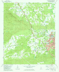
 1956 Birmingham1956 Print · USGSCentral Alabama in the mid-fifties exhibits a landscape of growing cities and deep-rooted industrial corridors. Genealogists and historians can trace the development of suburban Mountain Brook or locate regional hubs like Sylacauga and Jasper.
 - 1957 Map of Birmingham
 1957 Birmingham1957 Print · USGSNorth-Central Alabama in the mid-fifties is an industrial powerhouse centered on the steel valleys and sprawling iron ridges. Genealogists and historians can trace the rail-linked growth of Birmingham and Tuscaloosa, or locate rural landmarks like Talladega College and the Anniston Ordnance Depot.
 - 1975 Map of Goodwater SW, 1977 Print
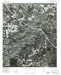 1975 Goodwater SW1977 Print · USGSCoosa County, Alabama is shown here at the height of the 1970s through high-contrast aerial imagery. Local researchers and genealogists can trace the rural road networks and land clearings surrounding Stewartville, Hollins, and Hanover.
 - 1975 Map of Goodwater NW, 1977 Print
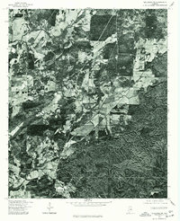
 1975 Goodwater NW1977 Print · USGSThe wooded ridges and valley floors of Talladega County are captured in this mid-seventies aerial survey during a period of local expansion. Genealogists and local historians can trace the precise 1975 footprints of Sylacauga and Sycamore against the dense Alabama forest.
 - 1975 Map of Talladega SW, 1977 Print
 1975 Talladega SW1977 Print · USGSTalladega County in the mid-seventies is documented here through precise aerial photography. Genealogists and local historians can trace the exact layout of rural homesteads and property lines around Winterboro, Sycamore, and Alpine.
 - 1979 Map of Weogufka, 1980 Print
 1979 Weogufka1980 Print · USGSIn the late seventies, this rural corner of Alabama shows a landscape defined by the ridges of Breastworks and the winding Weogufka Creek. Genealogists can trace family roots through several local landmarks like Grimes Chapel Cem and the Estelle Ch Cem.2 unique versions available
 - 1980 Map of Sylacauga West
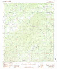
 1980 Sylacauga West1980 Print · USGSThe marble industrial corridor west of Sylacauga comes alive in the late 1970s, showing a landscape shaped by stone quarries and rail lines. Genealogists and local historians can trace family-named landmarks like Allen Cem, St Andrews Ch, and the high ridges of Kahatchee Mountain.
 - 1984 Map of Hollins
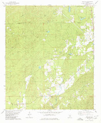
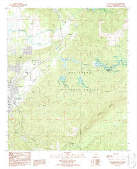
 1984 Hollins1984 Print · USGSCentrally located in Alabama during the mid-eighties, this area shows the intersection of three counties and the Central of Georgia line. Genealogists can locate family landmarks like Shiloh Ch, Mt Pleasant Cem, and Andrew Chapel.
 - 1984 Map of Birmingham South, 1985 Print
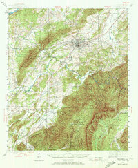
 1984 Birmingham South1985 Print · USGSThe Birmingham metropolitan region and the Coosa River valley are shown here in the mid-eighties as suburban growth expanded south into the ridges. Genealogists and local historians can trace the development of communities from Bessemer to Sylacauga alongside the Lay Lake shoreline and the Talladega National Forest.2 unique versions available
 - 1984 Map of Winterboro, 1985 Print
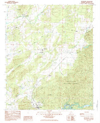 1984 Winterboro1985 Print · USGSTalladega County is shown in the early eighties as a landscape of forest and farm life shaped by the Southern and Seaboard railroads. Researchers can locate family landmarks like Africa Ch, Pittard Vocational Sch, and the community of Winterboro.
 - 1987 Map of Sylacauga East
 1987 Sylacauga East1987 Print · USGSTalladega County's eastern ridges and industrial fringes are captured here in the late eighties, just as the regional rail network was consolidating. Genealogists and historians can trace family-named sites like Evergreen Cem, Indian Valley Sch, and the community of Sycamore.
 - 2001 Map of Sylacauga East, 2004 Print
 2001 Sylacauga East2004 Print · USGSTalladega County at the start of the millennium reveals a landscape shaped by the ridges of the National Forest and the winding path of Tallaseehatchee Creek. Local researchers can trace the settlement of Sycamore and the geography of Rebecca Mountain or Emawhee Creek.
 - 2001 Map of Winterboro, 2004 Print
 2001 Winterboro2004 Print · USGSTalladega County at the turn of the twenty-first century reveals a landscape shaped by the Talladega National Forest and historic creek-side settlements. Genealogists can locate family landmarks such as the Mt Olive Ch, Pittard Vocational Sch, and the community of Winterboro.
 - 2001 Map of Hollins, 2004 Print
 2001 Hollins2004 Print · USGSTalladega and Coosa counties met at the dawn of the millennium in this detailed study of the forest-heavy Alabama interior. Genealogists and local historians can trace rural community life through landmarks like Mt Pleasant Cem, Shiloh Ch, and the settlement of Hanover.
 - 2011 Map of Hollins, 2011 Print
 2011 Hollins2011 Print · USGSCovers Sylacauga, including Stewartville, Hollins, and other nearby areas
 - 2011 Map of Weogufka, 2011 Print
 2011 Weogufka2011 Print · USGSCovers Sylacauga, including Weogufka, Unity, and other nearby areas
Showing maps 1-25 of 48
Top cities near Sylacauga
- Talladega historical maps
- Childersburg historical maps
- Vincent historical maps
- Wilsonville historical maps
- Westover historical maps
- Stewartville historical maps
See more
Top neighborhoods of Sylacauga
- Chico historical maps
- Lake Joy historical maps
- Walco historical maps
- Sunrise historical maps
- The Moon historical maps
Frequently asked questions
- What are the different types of historical maps available for Sylacauga?
- What is the oldest map of Sylacauga?
- Where can I purchase historical maps of Sylacauga for my home or office?
- Where can I download high-res historical maps of Sylacauga?
- Are there historical topographic maps available for Sylacauga?
- Is there historical aerial imagery available for Sylacauga?
- Where are historical maps of Sylacauga sourced from?