1970s Maps of Sylacauga, Alabama
Explore 4 historic maps of Sylacauga from the 1970s. These maps offer a rare glimpse into what life looked like during the 1970s — showing old roads, neighborhoods, homes, and landmarks that have changed or disappeared over time.
Whether you're researching your family's past, planning a metal detecting trip, or studying how Sylacauga's landscape evolved across the 1970s, these high-resolution maps are a powerful tool for exploring the history of this region.
- Focus on a specific era: All maps on this page are from the 1970s, giving you a focused view of this time period.
- See what’s changed: Compare century-old streets, trails, and buildings to today's modern landscape using overlays and satellite layers.
- Research with precision: Use these maps for genealogy, historical research, land use analysis, or educational projects.
- View, download, or print: Maps are fully viewable online in high resolution, and can be downloaded or printed for your own records.
Start exploring Sylacauga's history through authentic maps from the 1970s. This is your window into the past.
Sylacauga, AL maps
(4)- 1975 Map of Goodwater SW, 1977 Print
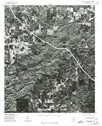 1975 Goodwater SW1977 Print · USGSCoosa County, Alabama is shown here at the height of the 1970s through high-contrast aerial imagery. Local researchers and genealogists can trace the rural road networks and land clearings surrounding Stewartville, Hollins, and Hanover.
 - 1975 Map of Goodwater NW, 1977 Print
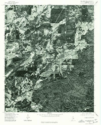
 1975 Goodwater NW1977 Print · USGSThe wooded ridges and valley floors of Talladega County are captured in this mid-seventies aerial survey during a period of local expansion. Genealogists and local historians can trace the precise 1975 footprints of Sylacauga and Sycamore against the dense Alabama forest.
 - 1975 Map of Talladega SW, 1977 Print
 1975 Talladega SW1977 Print · USGSTalladega County in the mid-seventies is documented here through precise aerial photography. Genealogists and local historians can trace the exact layout of rural homesteads and property lines around Winterboro, Sycamore, and Alpine.
 - 1979 Map of Weogufka, 1980 Print
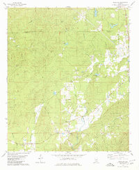 1979 Weogufka1980 Print · USGSIn the late seventies, this rural corner of Alabama shows a landscape defined by the ridges of Breastworks and the winding Weogufka Creek. Genealogists can trace family roots through several local landmarks like Grimes Chapel Cem and the Estelle Ch Cem.2 unique versions available
End of results
Showing maps 1-4 of 4
Top cities near Sylacauga
- Talladega historical maps
- Childersburg historical maps
- Vincent historical maps
- Wilsonville historical maps
- Westover historical maps
- Stewartville historical maps
See more
Top neighborhoods of Sylacauga
- Chico historical maps
- Lake Joy historical maps
- Walco historical maps
- Sunrise historical maps
- The Moon historical maps
Frequently asked questions
- What are the different types of historical maps available for Sylacauga?
- What is the oldest map of Sylacauga?
- Where can I purchase historical maps of Sylacauga for my home or office?
- Where can I download high-res historical maps of Sylacauga?
- Are there historical topographic maps available for Sylacauga?
- Is there historical aerial imagery available for Sylacauga?
- Where are historical maps of Sylacauga sourced from?