1970s Maps of Alexander City, Alabama
Explore 5 historic maps of Alexander City from the 1970s. These maps offer a rare glimpse into what life looked like during the 1970s — showing old roads, neighborhoods, homes, and landmarks that have changed or disappeared over time.
Whether you're researching your family's past, planning a metal detecting trip, or studying how Alexander City's landscape evolved across the 1970s, these high-resolution maps are a powerful tool for exploring the history of this region.
- Focus on a specific era: All maps on this page are from the 1970s, giving you a focused view of this time period.
- See what’s changed: Compare century-old streets, trails, and buildings to today's modern landscape using overlays and satellite layers.
- Research with precision: Use these maps for genealogy, historical research, land use analysis, or educational projects.
- View, download, or print: Maps are fully viewable online in high resolution, and can be downloaded or printed for your own records.
Start exploring Alexander City's history through authentic maps from the 1970s. This is your window into the past.
Alexander City, AL maps
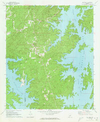
(5)- 1971 Map of Dadeville, 1973 Print
 1971 Dadeville1973 Print · USGSTallapoosa County's landscape in the early 1970s is defined by the reaching waters of Martin Lake and the established rail lines of the Central of Georgia. Genealogists can locate family landmarks like Spain Cem and Williams Cem, or trace rural congregations at Mt Zion Ch and Sandy Creek Ch.3 unique versions available
 - 1971 Map of Alexander City, 1973 Print
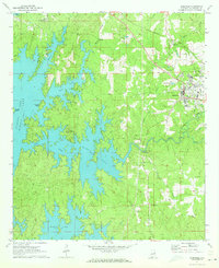
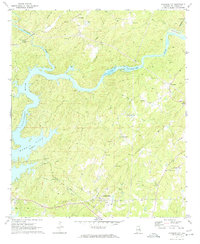
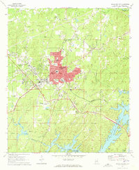 1971 Alexander City1973 Print · USGSAlexander City and the northern shores of Martin Lake are captured here in the early seventies during a period of steady growth. Researchers can trace the town's expansion through sites like Alexander City, Russell High Sch, and Wind Creek State Park.3 unique versions available
 - 1971 Map of Our Town, 1973 Print
 1971 Our Town1973 Print · USGSTallapoosa County and the winding shores of Martin Lake are captured here in the early seventies as recreation and local life converged. Genealogists can trace family names at Mt Zion Cem and Mask Cem or locate the rural settlement of Our Town.2 unique versions available
 - 1971 Map of Kellyton, 1973 Print
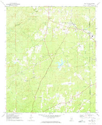 1971 Kellyton1973 Print · USGSCentral Alabama's rural landscape is captured here in the early seventies, centered on the railroad community of Kellyton. Local historians can trace family roots through numerous sites like Socapatoy Cem, Bradford Ch, and Jordan Cem.2 unique versions available
 - 1971 Map of Jacksons Gap, 1974 Print
 1971 Jacksons Gap1974 Print · USGSThe Tallapoosa River and Martin Lake define this Alabama landscape in the early seventies as the region balanced rural tradition with growing lakeside recreation. Genealogists can trace family landmarks like Rocky Mount Ch, Fosheeton, and the Central of Georgia rail corridor.2 unique versions available
End of results
Showing maps 1-5 of 5
Top cities near Alexander City
- Dadeville historical maps
- Goodwater historical maps
- Eclectic historical maps
- New Site historical maps
- Jacksons' Gap historical maps
- Our Town historical maps
See more
Top neighborhoods of Alexander City
- Midway historical maps
- Indian Hills historical maps
- Mount Zion historical maps
- White Oak Landing historical maps
- Fuller historical maps
- Lake Hill Estates historical maps
See more
Frequently asked questions
- What are the different types of historical maps available for Alexander City?
- What is the oldest map of Alexander City?
- Where can I purchase historical maps of Alexander City for my home or office?
- Where can I download high-res historical maps of Alexander City?
- Are there historical topographic maps available for Alexander City?
- Is there historical aerial imagery available for Alexander City?
- Where are historical maps of Alexander City sourced from?