1890s Maps of Tuscaloosa County, Alabama
Explore 2 historic maps of Tuscaloosa County from the 1890s. These maps offer a rare glimpse into what life looked like during the 1890s — showing old roads, neighborhoods, homes, and landmarks that have changed or disappeared over time.
Whether you're researching your family's past, planning a metal detecting trip, or studying how Tuscaloosa County's landscape evolved across the 1890s, these high-resolution maps are a powerful tool for exploring the history of this region.
- Focus on a specific era: All maps on this page are from the 1890s, giving you a focused view of this time period.
- See what’s changed: Compare century-old streets, trails, and buildings to today's modern landscape using overlays and satellite layers.
- Research with precision: Use these maps for genealogy, historical research, land use analysis, or educational projects.
- View, download, or print: Maps are fully viewable online in high resolution, and can be downloaded or printed for your own records.
Start exploring Tuscaloosa County's history through authentic maps from the 1890s. This is your window into the past.
Tuscaloosa County, AL maps
(2)- 1893 Map of Jasper
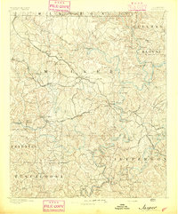 1893 Jasper1893 Print · USGSNorthern Alabama’s coal and timber country comes into focus in the 1890s as railroads began to penetrate the river valleys. Genealogists and historians can trace family-named river crossings like Miller Ferry and Baltimore Ford or early industry at Gamble Mines.5 unique versions available
 - 1899 Map of Brookwood
 1899 Brookwood1899 Print · USGSCentral Alabama at the close of the nineteenth century is a landscape of growing mining towns and vital river crossings. Trace the early industrial rail lines like the Birmingham Mineral R. R. and locate family landmarks such as Weaver Mill, Pratt Ferry, and Providence Ch.4 unique versions available
End of results
Showing maps 1-2 of 2
Top cities of Tuscaloosa County
- Tuscaloosa historical maps
- Northport historical maps
- Abernant historical maps
- Lake View historical maps
- Holt historical maps
- Brookwood historical maps
See more
Frequently asked questions
- What are the different types of historical maps available for Tuscaloosa County?
- What is the oldest map of Tuscaloosa County?
- Where can I purchase historical maps of Tuscaloosa County for my home or office?
- Where can I download high-res historical maps of Tuscaloosa County?
- Are there historical topographic maps available for Tuscaloosa County?
- Is there historical aerial imagery available for Tuscaloosa County?
- Where are historical maps of Tuscaloosa County sourced from?