1920s Maps of Tuscaloosa County, Alabama
Explore 6 historic maps of Tuscaloosa County from the 1920s. These maps offer a rare glimpse into what life looked like during the 1920s — showing old roads, neighborhoods, homes, and landmarks that have changed or disappeared over time.
Whether you're researching your family's past, planning a metal detecting trip, or studying how Tuscaloosa County's landscape evolved across the 1920s, these high-resolution maps are a powerful tool for exploring the history of this region.
- Focus on a specific era: All maps on this page are from the 1920s, giving you a focused view of this time period.
- See what’s changed: Compare century-old streets, trails, and buildings to today's modern landscape using overlays and satellite layers.
- Research with precision: Use these maps for genealogy, historical research, land use analysis, or educational projects.
- View, download, or print: Maps are fully viewable online in high resolution, and can be downloaded or printed for your own records.
Start exploring Tuscaloosa County's history through authentic maps from the 1920s. This is your window into the past.
Tuscaloosa County, AL maps
(6)- 1924 Map of Tuscaloosa, 1957 Print
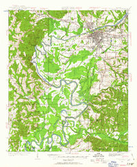 1924 Tuscaloosa1957 Print · USGSTuscaloosa and the Black Warrior River valley are seen here in the mid-1920s, showing a landscape defined by river bends and rail lines. Researchers can trace the early footprint of the University of Alabama or locate rural sites like Cribbs Mill and Little Satan Church.
 - 1926 Map of Samantha
 1926 Samantha1926 Print · USGSTuscaloosa County is captured here in the mid-1920s, showing a landscape of rural schoolhouses and family-run stores along the North River. Genealogists can locate specific community centers like Windham Springs, Oregonian School, and Barnett's Store.
 - 1926 Map of Tuscaloosa
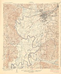 1926 Tuscaloosa1926 Print · USGSCentral Alabama's river-and-rail landscape is captured here during the mid-twenties, showcasing the growth of the University of Alabama and Tuscaloosa. Genealogists and historians can trace family-named sites like Carson Bluff Bend and rural landmarks such as Coker, Kings Ferry, and the Hull Consolidated School.3 unique versions available
 - 1927 Map of Adger
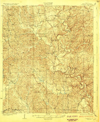
 1927 Adger1927 Print · USGSThe industrial heart of Alabama comes alive in the late twenties, showing the intersection of mining and rail. Genealogists can trace family roots at Concord Ch, Connellsville Mine, and the early settlement at Tannehill.
 - 1928 Map of Samantha
 1928 Samantha1928 Print · USGSNorthern Tuscaloosa County is captured here in the late 1920s, showing a landscape defined by the North River and the historic Byler Road. Genealogists can trace family roots through numerous local landmarks like Samantha, Bell City, and Haywood Chapel.6 unique versions available
 - 1929 Map of Searles
 1929 Searles1929 Print · USGSTuscaloosa and Jefferson counties are shown here in the late twenties during a period of heavy coal production and river navigation. You can trace the industrial footprint of the Encora Mine, locate East Kellerman, and find the Piney Grove Ch Cem.
End of results
Showing maps 1-6 of 6
Top cities of Tuscaloosa County
- Tuscaloosa historical maps
- Northport historical maps
- Abernant historical maps
- Lake View historical maps
- Holt historical maps
- Brookwood historical maps
See more
Frequently asked questions
- What are the different types of historical maps available for Tuscaloosa County?
- What is the oldest map of Tuscaloosa County?
- Where can I purchase historical maps of Tuscaloosa County for my home or office?
- Where can I download high-res historical maps of Tuscaloosa County?
- Are there historical topographic maps available for Tuscaloosa County?
- Is there historical aerial imagery available for Tuscaloosa County?
- Where are historical maps of Tuscaloosa County sourced from?