1960s Maps of Tuscaloosa County, Alabama
Explore 11 historic maps of Tuscaloosa County from the 1960s. These maps offer a rare glimpse into what life looked like during the 1960s — showing old roads, neighborhoods, homes, and landmarks that have changed or disappeared over time.
Whether you're researching your family's past, planning a metal detecting trip, or studying how Tuscaloosa County's landscape evolved across the 1960s, these high-resolution maps are a powerful tool for exploring the history of this region.
- Focus on a specific era: All maps on this page are from the 1960s, giving you a focused view of this time period.
- See what’s changed: Compare century-old streets, trails, and buildings to today's modern landscape using overlays and satellite layers.
- Research with precision: Use these maps for genealogy, historical research, land use analysis, or educational projects.
- View, download, or print: Maps are fully viewable online in high resolution, and can be downloaded or printed for your own records.
Start exploring Tuscaloosa County's history through authentic maps from the 1960s. This is your window into the past.
Tuscaloosa County, AL maps
(11)- 1967 Map of Brownville, 1968 Print
 1967 Brownville1968 Print · USGSThe rural border of Pickens and Tuscaloosa Counties is documented here in the late sixties, showcasing a landscape of river-bottom wetlands and timbered ridges. Genealogists can locate numerous community landmarks like Shelton Chapel, Winn Cem, and the Old Railroad Grade.2 unique versions available
 - 1967 Map of Newtonville, 1968 Print
 1967 Newtonville1968 Print · USGSThe rural borderlands of Fayette and Tuscaloosa counties are captured here in the late sixties, centered on the community of Newtonville. Genealogists can trace family landmarks and burial sites like Brotherton Cemetery and Gravlee Cemetery or locate the Newtonville School.3 unique versions available
 - 1967 Map of Elrod, 1968 Print
 1967 Elrod1968 Print · USGSTuscaloosa and Pickens Counties are captured here in the late sixties, as rural life centered on the Gulf Mobile and Ohio railroad. Genealogists and local historians can trace family-named sites like Wilburn Cem, Echola, and Shirley Bridge along the Sipsey River.2 unique versions available
 - 1967 Map of New Lexington, 1968 Print
 1967 New Lexington1968 Print · USGSThe borderlands of Fayette and Tuscaloosa Counties are mapped here in the late sixties, showing a landscape defined by the North River. Genealogists can trace family footprints at New Lexington and numerous landmarks like Ethels Sch and Tucker Cem.2 unique versions available
 - 1967 Map of Berry SE, 1968 Print
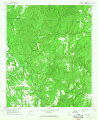 1967 Berry SE1968 Print · USGSThe Fayette and Tuscaloosa county line follows the winding course of the North River during the late sixties. Genealogists and local historians can trace family ties through rural landmarks like Gorgas Sch, Sulphur Springs Ch, and the Willingham Cem.4 unique versions available
 - 1969 Map of Duncanville, 1972 Print
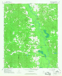
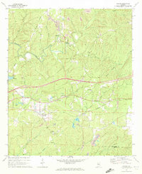
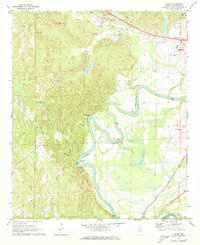
 1969 Duncanville1972 Print · USGSDuncanville and the surrounding Tuscaloosa County hinterlands are shown here in the late sixties as the timber and rail industries shaped the local landscape. Genealogists can locate family landmarks like Mt Sinai Ch Cem, South Sandy Cem, and the Shiloh Lookout Tower.3 unique versions available
 - 1969 Map of Pearson, 1972 Print
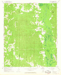
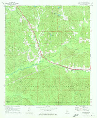
 1969 Pearson1972 Print · USGSBibb and Tuscaloosa Counties in the late sixties were defined by the heavy rail traffic of the Gulf Mobile and Ohio and the deep woods of the Talladega National Forest. Genealogists and local historians can trace the rural communities around Hagler, Pearson, and landmarks like Hubbard Springs Ch.3 unique versions available
 - 1969 Map of Coaling, 1972 Print
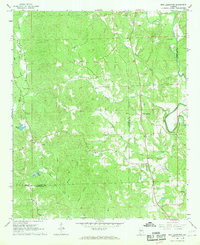
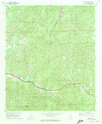
 1969 Coaling1972 Print · USGSThe hills of Tuscaloosa County are shown during the late sixties, a landscape where the Southern railroad line connects rural coal-mining centers. Genealogists can trace family names at Thomas Chapel (Cem), Pineview Sch, and the community of Coaling.3 unique versions available
 - 1969 Map of Fosters, 1973 Print
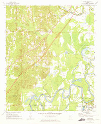 1969 Fosters1973 Print · USGSThe Black Warrior River valley near Tuscaloosa was undergoing major change in the late sixties as new highways were built through the bottomlands. Researchers can locate the Indian Mounds at Moundville or trace family sites like Myrtlewood Sch and Dry Creek Ch.2 unique versions available
 - 1969 Map of Coker, 1973 Print
 1969 Coker1973 Print · USGSThe Black Warrior River's deep meanders and the rural community of Coker are captured here in the late sixties. Trace the river's path through Snows Bend or locate local landmarks like Cornelius Chapel, Bryce Hospital, and the Mobile and Ohio rail line.3 unique versions available
 - 1969 Map of Cottondale, 1973 Print
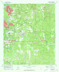 1969 Cottondale1973 Print · USGSEast of Tuscaloosa in the late sixties, the landscape was a mix of growing suburbs and active coal extraction along the rail corridors. Researchers can locate family landmarks like Kennedy Chapel, the Boteler High Sch, and various Strip Mines near Peterson.3 unique versions available
End of results
Showing maps 1-11 of 11
Top cities of Tuscaloosa County
- Tuscaloosa historical maps
- Northport historical maps
- Abernant historical maps
- Lake View historical maps
- Holt historical maps
- Brookwood historical maps
See more
Frequently asked questions
- What are the different types of historical maps available for Tuscaloosa County?
- What is the oldest map of Tuscaloosa County?
- Where can I purchase historical maps of Tuscaloosa County for my home or office?
- Where can I download high-res historical maps of Tuscaloosa County?
- Are there historical topographic maps available for Tuscaloosa County?
- Is there historical aerial imagery available for Tuscaloosa County?
- Where are historical maps of Tuscaloosa County sourced from?