
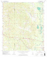
1967 Map of Elrod
USGS Topo · Published 1968About this map
The Gulf Mobile and Ohio railroad corridor anchors the southern landscape of this 1967 survey, linking the small communities of Holman, Elrod, and Buhl. Situated along the border of Pickens and Tuscaloosa Counties, the terrain is defined by the winding course of the Sipsey River and its complex network of swampy backwaters, including Cooper Slough and Springer Slough. The rural character of the era is evident in the numerous country churches and family burial grounds that dot the ridges above the river valley.
Find a feature on this map
40 named features on this map. Tap any name to fly to it.
Don’t see what you’re looking for? This feature index may not catch every label — zoom into the map to look around manually.
Map Details
Editions of this 1967 Elrod Map
2 editions found
Other maps of this area

1924 · Tuscaloosa
USGS Topo · 1:62,500

1926 · Samantha
USGS Topo · 1:48,000

1926 · Tuscaloosa
USGS Topo · 1:62,500

1928 · Samantha
USGS Topo · 1:62,500

1953 · Birmingham
USGS Topo · 1:250,000

1956 · Birmingham
USGS Topo · 1:250,000

1957 · Birmingham
USGS Topo · 1:250,000

1967 · Brownville
USGS Topo · 1:24,000

1967 · Gordo
USGS Topo · 1:24,000
1967 · Palmetto
USGS Topo · 1:24,000