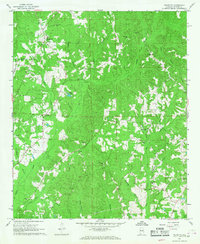
1967 Map of Palmetto
USGS Topo · Published 1968About this map
Palmetto and its surrounding countryside in Pickens County are defined by a complex network of creek branches and rural congregations. The landscape is heavily dissected by waterways such as Lubbub Creek, Linebarger Creek, and Beaver Creek, creating a terrain where community life historically centered around small churches and family burial grounds. Notable landmarks include the Unity Grove Ch in the northwest and Shiloh Ch to the southeast. Local industry at the time of this late-1960s survey is represented by scattered Gravel Pits, while the agricultural character of the region is emphasized by the inclusion of fence and field lines. These details, combined with the presence of Mt Tabor Cem and Big Hill Cem, offer a clear look at the mid-century rural settlement patterns of this Alabama interior.
Find a feature on this map
32 named features on this map. Tap any name to fly to it.
Don’t see what you’re looking for? This feature index may not catch every label — zoom into the map to look around manually.
Map Details
Editions of this 1967 Palmetto Map
2 editions found
Other maps of this area

1953 · Birmingham
USGS Topo · 1:250,000

1953 · West Point
USGS Topo · 1:250,000

1956 · Birmingham
USGS Topo · 1:250,000

1957 · Birmingham
USGS Topo · 1:250,000

1958 · West Point
USGS Topo · 1:250,000

1963 · West Point
USGS Topo · 1:250,000

1967 · Carrollton
USGS Topo · 1:24,000

1967 · Brownville
USGS Topo · 1:24,000

1967 · Newtonville
USGS Topo · 1:24,000

1967 · Kennedy
USGS Topo · 1:24,000