
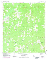
1967 Map of Kennedy
USGS Topo · Published 1968About this map
Kennedy serves as the primary hub in this West Alabama landscape, situated near the intersection of the Southern RR railroad line and the Luxapallila Creek valley. The terrain is defined by a complex drainage system where several major waterways, including Coal Fire Creek, Bear Creek, and Lubbub Creek, converge near the borders of Lamar, Fayette, and Pickens Counties. This mid-century survey reveals a rural society structured around numerous small community landmarks, particularly country churches and family-named cemeteries that dot the high ground between the creek bottoms.
Find a feature on this map
35 named features on this map. Tap any name to fly to it.
Don’t see what you’re looking for? This feature index may not catch every label — zoom into the map to look around manually.
Map Details
Editions of this 1967 Kennedy Map
2 editions found
Other maps of this area

1953 · Birmingham
USGS Topo · 1:250,000

1953 · West Point
USGS Topo · 1:250,000

1956 · Birmingham
USGS Topo · 1:250,000

1957 · Birmingham
USGS Topo · 1:250,000

1958 · West Point
USGS Topo · 1:250,000

1963 · West Point
USGS Topo · 1:250,000

1967 · Brownville
USGS Topo · 1:24,000

1967 · Newtonville
USGS Topo · 1:24,000

1967 · Hightogy
USGS Topo · 1:24,000

1967 · Millport
USGS Topo · 1:24,000