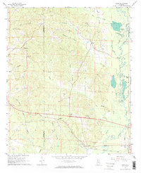
1967 Map of Elrod
USGS Topo · Published 1968About this map
The Sipsey River and its complex network of oxbows and sloughs, including Oak Log Slough and Springer Slough, dominate the eastern landscape of this West Alabama quadrangle. The Gulf Mobile and Ohio railroad corridor anchors the southern settlements of Elrod and Buhl, providing a vital transportation artery through the lowlands. This mid-century survey reveals a rural society structured around local gathering places, with several family and community landmarks such as Freeman Cem, Wilburn Cem, and the Bethlehem Ch appearing across the terrain. Further north, the upland ridges are defined by watercourses like Eightmile Branch and the small community of Echola. The map preserves the exact alignment of rural roads and the location of isolated churches like Corinth Ch and Mt Nebo Ch before later development altered the rural character of the Pickens and Tuscaloosa County border.
Find a feature on this map
45 named features on this map. Tap any name to fly to it.
Don’t see what you’re looking for? This feature index may not catch every label — zoom into the map to look around manually.
Map Details
Editions of this 1967 Elrod Map
2 editions found

Other maps of this area

1924 · Tuscaloosa
USGS Topo · 1:62,500

1926 · Samantha
USGS Topo · 1:48,000

1926 · Tuscaloosa
USGS Topo · 1:62,500

1928 · Samantha
USGS Topo · 1:62,500

1953 · Birmingham
USGS Topo · 1:250,000

1956 · Birmingham
USGS Topo · 1:250,000

1957 · Birmingham
USGS Topo · 1:250,000

1967 · Brownville
USGS Topo · 1:24,000

1967 · Gordo
USGS Topo · 1:24,000
1967 · Palmetto
USGS Topo · 1:24,000