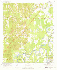
1969 Map of Fosters
USGS Topo · Published 1973About this map
Moundville and the State Monument anchor the southern reaches of this landscape, where the Indian Mounds and an onsite Museum mark a significant archaeological site near the Southern railroad line. The Black Warrior River meanders through the center of the sheet, creating complex water features like Toxy Bend and Hemphill Bend. This 1969 field-checked survey captures a moment of infrastructure development, explicitly labeling a highway under construction that cuts diagonally across the terrain toward the Foster Ferry Bridge. Inland from the river, rural life is defined by a network of small community centers such as Fosters, Myrtlewood Sch, and numerous country churches including Holy Springs Ch and Grant Creek Ch. The presence of a Fish Hatchery near Cypress Pond and various oxbow lakes like Moon Lake suggests a landscape deeply tied to the river's shifting path and the local aquatic economy.
Find a feature on this map
41 named features on this map. Tap any name to fly to it.
Don’t see what you’re looking for? This feature index may not catch every label — zoom into the map to look around manually.
Map Details
Editions of this 1969 Fosters Map
2 editions found
Other maps of this area

1924 · Tuscaloosa
USGS Topo · 1:62,500

1926 · Tuscaloosa
USGS Topo · 1:62,500

1927 · Eutaw
USGS Topo · 1:48,000

1931 · Eutaw
USGS Topo · 1:62,500

1953 · Montgomery
USGS Topo · 1:250,000

1953 · Birmingham
USGS Topo · 1:250,000

1956 · Birmingham
USGS Topo · 1:250,000

1956 · Montgomery
USGS Topo · 1:250,000

1957 · Birmingham
USGS Topo · 1:250,000

1957 · Montgomery
USGS Topo · 1:250,000