
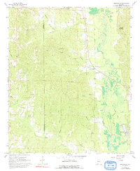
1967 Map of Brownville
USGS Topo · Published 1968About this map
The Sipsey River meanders through the eastern portions of this quadrangle, defining a landscape of low-lying wetlands and complex creek systems like Thornton Creek and Buck Creek. In the late 1960s, the settlement of Brownville stands near the river, served by a Water Tank and an Old Railroad Grade that speaks to the area's earlier timber or transit history. The terrain rises to the west toward Phillips Mountain, which is topped by a Lookout Tower for forest surveillance.
Find a feature on this map
31 named features on this map. Tap any name to fly to it.
Don’t see what you’re looking for? This feature index may not catch every label — zoom into the map to look around manually.
Map Details
Editions of this 1967 Brownville Map
2 editions found
Other maps of this area

1926 · Samantha
USGS Topo · 1:48,000

1928 · Samantha
USGS Topo · 1:62,500

1953 · Birmingham
USGS Topo · 1:250,000

1956 · Birmingham
USGS Topo · 1:250,000

1957 · Birmingham
USGS Topo · 1:250,000

1967 · Newtonville
USGS Topo · 1:24,000

1967 · Kennedy
USGS Topo · 1:24,000

1967 · Gordo
USGS Topo · 1:24,000
1967 · Palmetto
USGS Topo · 1:24,000

1967 · Elrod
USGS Topo · 1:24,000