Old Maps of Tuscaloosa, Alabama for Metal Detecting
Plan your next treasure hunt with 76 historic maps of Tuscaloosa. Find old homesites, ghost towns, trails, and gathering spots that may be lost to time — perfect for identifying promising metal detecting locations.
- Locate forgotten sites: Uncover places like long-lost settlements, abandoned rail lines, or gathering spots.
- Plan better hunts: Use map overlays combined with LiDAR or satellite views to narrow in on historically rich areas.
- Made for detectorists: Thousands of hobbyists use these maps to discover relics, coins, and hidden history.
Use these historic maps to boost your research and find new opportunities beneath the surface of Tuscaloosa.
Tuscaloosa, AL maps
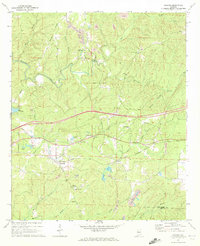
(76)- 1899 Map of Brookwood
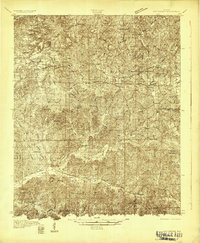
 1899 Brookwood1899 Print · USGSCentral Alabama at the close of the nineteenth century is a landscape of growing mining towns and vital river crossings. Trace the early industrial rail lines like the Birmingham Mineral R. R. and locate family landmarks such as Weaver Mill, Pratt Ferry, and Providence Ch.4 unique versions available
 - 1924 Map of Tuscaloosa, 1957 Print
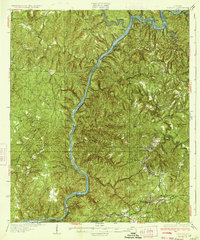
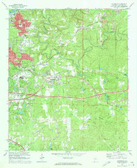
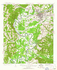 1924 Tuscaloosa1957 Print · USGSTuscaloosa and the Black Warrior River valley are seen here in the mid-1920s, showing a landscape defined by river bends and rail lines. Researchers can trace the early footprint of the University of Alabama or locate rural sites like Cribbs Mill and Little Satan Church.
 - 1926 Map of Samantha
 1926 Samantha1926 Print · USGSTuscaloosa County is captured here in the mid-1920s, showing a landscape of rural schoolhouses and family-run stores along the North River. Genealogists can locate specific community centers like Windham Springs, Oregonian School, and Barnett's Store.
 - 1926 Map of Tuscaloosa
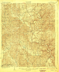
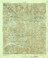
 1926 Tuscaloosa1926 Print · USGSCentral Alabama's river-and-rail landscape is captured here during the mid-twenties, showcasing the growth of the University of Alabama and Tuscaloosa. Genealogists and historians can trace family-named sites like Carson Bluff Bend and rural landmarks such as Coker, Kings Ferry, and the Hull Consolidated School.3 unique versions available
 - 1928 Map of Samantha
 1928 Samantha1928 Print · USGSNorthern Tuscaloosa County is captured here in the late 1920s, showing a landscape defined by the North River and the historic Byler Road. Genealogists can trace family roots through numerous local landmarks like Samantha, Bell City, and Haywood Chapel.6 unique versions available
 - 1929 Map of Searles
 1929 Searles1929 Print · USGSTuscaloosa and Jefferson counties are shown here in the late twenties during a period of heavy coal production and river navigation. You can trace the industrial footprint of the Encora Mine, locate East Kellerman, and find the Piney Grove Ch Cem.
 - 1931 Map of Cottondale
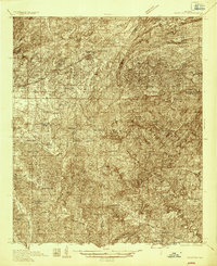
 1931 Cottondale1931 Print · USGSTuscaloosa County at the start of the 1930s shows a landscape of timber rails and rural churches. Genealogists and historians can trace the Kaul Lumber Co (Abandoned) line or locate old community centers like Andrews Chapel and Duncanville.
 - 1934 Map of Searles
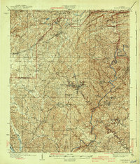
 1934 Searles1934 Print · USGSThe industrial hills and river locks of Tuscaloosa and Jefferson counties are captured here in the early 1930s. Genealogists can trace family roots in mining settlements like Searles and Kellerman, or locate rural landmarks such as Antioch Ch & Cem.6 unique versions available
 - 1934 Map of Cottondale
 1934 Cottondale1934 Print · USGSDuring the mid-1930s, the rail corridors of the Southern Railway and Mobile and Ohio Railroad shaped the growth of eastern Tuscaloosa County. Genealogists can trace family footprints near Cottondale and Duncanville or locate long-standing landmarks like Emerson Chapel and Howell Sch.3 unique versions available
 - 1934 Map of Blocton
 1934 Blocton1934 Print · USGSCentral Alabama's coal and rail corridor comes to life in the 1930s, showing the intersection of the Cahaba River and intensive industrial development. Researchers can locate old mining sites like Hill Creek Mine and numerous rural landmarks including Rock Institute Sch and Ada Chapel.3 unique versions available
 - 1940 Map of Blocton
 1940 Blocton1940 Print · USGSCentral Alabama's mining and river country is captured here just before the Second World War, centered on the coal hubs of Bibb County. Researchers can trace family roots through numerous rural landmarks like Mt Olivet Ch, Gray Hill Sch, and the rail junction at Blocton Junc.2 unique versions available
 - 1953 Map of Birmingham, 1964 Print
 1953 Birmingham1964 Print · USGSCentral Alabama at mid-century shows a landscape defined by industrial expansion and the iron-rich ridges surrounding Birmingham. Researchers can trace the extensive rail networks of the L & N RR or locate historic federal sites like the Anniston Ordnance Depot.4 unique versions available
 - 1956 Map of Birmingham
 1956 Birmingham1956 Print · USGSCentral Alabama in the mid-fifties exhibits a landscape of growing cities and deep-rooted industrial corridors. Genealogists and historians can trace the development of suburban Mountain Brook or locate regional hubs like Sylacauga and Jasper.
 - 1957 Map of Birmingham
 1957 Birmingham1957 Print · USGSNorth-Central Alabama in the mid-fifties is an industrial powerhouse centered on the steel valleys and sprawling iron ridges. Genealogists and historians can trace the rail-linked growth of Birmingham and Tuscaloosa, or locate rural landmarks like Talladega College and the Anniston Ordnance Depot.
 - 1969 Map of Coaling, 1972 Print
 1969 Coaling1972 Print · USGSThe hills of Tuscaloosa County are shown during the late sixties, a landscape where the Southern railroad line connects rural coal-mining centers. Genealogists can trace family names at Thomas Chapel (Cem), Pineview Sch, and the community of Coaling.3 unique versions available
 - 1969 Map of Coker, 1973 Print
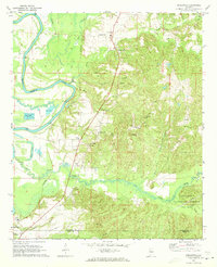
 1969 Coker1973 Print · USGSThe Black Warrior River's deep meanders and the rural community of Coker are captured here in the late sixties. Trace the river's path through Snows Bend or locate local landmarks like Cornelius Chapel, Bryce Hospital, and the Mobile and Ohio rail line.3 unique versions available
 - 1969 Map of Cottondale, 1973 Print
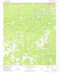
 1969 Cottondale1973 Print · USGSEast of Tuscaloosa in the late sixties, the landscape was a mix of growing suburbs and active coal extraction along the rail corridors. Researchers can locate family landmarks like Kennedy Chapel, the Boteler High Sch, and various Strip Mines near Peterson.3 unique versions available
 - 1970 Map of Englewood, 1973 Print
 1970 Englewood1973 Print · USGSThe Black Warrior River valley and the Talladega National Forest meet in this 1970s survey of the Alabama borderlands. Researchers can trace rural lineages through numerous country churches like Zion Hope Ch or locate the ancient mounds at Mound State Mon.4 unique versions available
 - 1971 Map of Tuscaloosa, 1973 Print
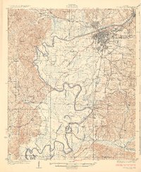
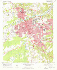 1971 Tuscaloosa1973 Print · USGSTuscaloosa and Northport are shown at a peak of institutional growth in the early seventies, centered on the Black Warrior River. Trace the mid-century footprints of the University of Alabama, Bryce Hospital, and local landmarks like Stillman College.5 unique versions available
 - 1974 Map of Lake Nicol
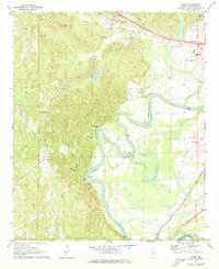
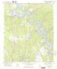
 1974 Lake Nicol1974 Print · USGSThe Black Warrior River valley near Tuscaloosa is shown here in the mid-seventies, just as energy and mining shaped the local economy. Genealogists and researchers can locate Center Church, Camp Cherry Austin, and numerous strip mines across the landscape.
 - 1978 Map of Gin Creek, 1979 Print
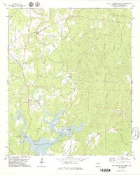
 1978 Gin Creek1979 Print · USGSTuscaloosa County remained a landscape of family farms and country churches in the 1970s. Local researchers can locate family burial plots at Espy Cem or Kemp Cem and trace the rural road network connecting Bethabara Ch and Northside High Sch.
 - 1978 Map of Lake Tuscaloosa North, 1979 Print
 1978 Lake Tuscaloosa North1979 Print · USGSNorthern Tuscaloosa County comes into focus in the late seventies as the North River feeds into the expanding reservoir. Trace family roots and local history at landmarks like Samantha, Old Prewitte Cem, and Arbor Springs Ch.3 unique versions available
 - 1978 Map of Lake Tuscaloosa South, 1979 Print
 1978 Lake Tuscaloosa South1979 Print · USGSNorthport and the southern reaches of Lake Tuscaloosa are captured here in the late seventies as the region's landscape was being reshaped by the reservoir. Genealogists and local researchers can locate numerous landmarks including Shirley Cem, Macedonia Ch, and the winding path of Old Byler Road.3 unique versions available
 - 1980 Map of Woodstock
 1980 Woodstock1980 Print · USGSThe Bibb and Tuscaloosa county line in the late seventies is a landscape defined by heavy rail transit and deep-rooted rural communities. Genealogists and historians can trace family sites like Shuttlesworth Cem, Union Cumberland Ch, and the old Old Grade roadbed.2 unique versions available
 - 1984 Map of Tuscaloosa, 1985 Print
 1984 Tuscaloosa1985 Print · USGSWest-central Alabama centers on the mid-1980s expansion of the university and the river economy. Genealogists and historians can trace small-town connections through Burchfield Store, North Johns, and the rail lines of the Southern railroad.2 unique versions available
Showing maps 1-25 of 76
Top cities near Tuscaloosa
- Northport historical maps
- Holt historical maps
- Cottondale historical maps
- Brookwood historical maps
- Vance historical maps
- Coaling historical maps
See more
Top neighborhoods of Tuscaloosa
- Driftwood Estates historical maps
- Dunbrook historical maps
- Four Winds historical maps
- Grand Arbor historical maps
- Shamley Green historical maps
- The Gates of Wellington historical maps
See more
Frequently asked questions
- What are the different types of historical maps available for Tuscaloosa?
- What is the oldest map of Tuscaloosa?
- Where can I purchase historical maps of Tuscaloosa for my home or office?
- Where can I download high-res historical maps of Tuscaloosa?
- Are there historical topographic maps available for Tuscaloosa?
- Is there historical aerial imagery available for Tuscaloosa?
- Where are historical maps of Tuscaloosa sourced from?