1970s Maps of Tuscaloosa, Alabama
Explore 6 historic maps of Tuscaloosa from the 1970s. These maps offer a rare glimpse into what life looked like during the 1970s — showing old roads, neighborhoods, homes, and landmarks that have changed or disappeared over time.
Whether you're researching your family's past, planning a metal detecting trip, or studying how Tuscaloosa's landscape evolved across the 1970s, these high-resolution maps are a powerful tool for exploring the history of this region.
- Focus on a specific era: All maps on this page are from the 1970s, giving you a focused view of this time period.
- See what’s changed: Compare century-old streets, trails, and buildings to today's modern landscape using overlays and satellite layers.
- Research with precision: Use these maps for genealogy, historical research, land use analysis, or educational projects.
- View, download, or print: Maps are fully viewable online in high resolution, and can be downloaded or printed for your own records.
Start exploring Tuscaloosa's history through authentic maps from the 1970s. This is your window into the past.
Tuscaloosa, AL maps
(6)- 1970 Map of Englewood, 1973 Print
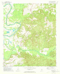 1970 Englewood1973 Print · USGSThe Black Warrior River valley and the Talladega National Forest meet in this 1970s survey of the Alabama borderlands. Researchers can trace rural lineages through numerous country churches like Zion Hope Ch or locate the ancient mounds at Mound State Mon.4 unique versions available
 - 1971 Map of Tuscaloosa, 1973 Print
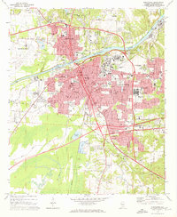 1971 Tuscaloosa1973 Print · USGSTuscaloosa and Northport are shown at a peak of institutional growth in the early seventies, centered on the Black Warrior River. Trace the mid-century footprints of the University of Alabama, Bryce Hospital, and local landmarks like Stillman College.5 unique versions available
 - 1974 Map of Lake Nicol
 1974 Lake Nicol1974 Print · USGSThe Black Warrior River valley near Tuscaloosa is shown here in the mid-seventies, just as energy and mining shaped the local economy. Genealogists and researchers can locate Center Church, Camp Cherry Austin, and numerous strip mines across the landscape.
 - 1978 Map of Gin Creek, 1979 Print
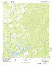
 1978 Gin Creek1979 Print · USGSTuscaloosa County remained a landscape of family farms and country churches in the 1970s. Local researchers can locate family burial plots at Espy Cem or Kemp Cem and trace the rural road network connecting Bethabara Ch and Northside High Sch.
 - 1978 Map of Lake Tuscaloosa North, 1979 Print
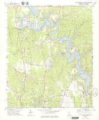
 1978 Lake Tuscaloosa North1979 Print · USGSNorthern Tuscaloosa County comes into focus in the late seventies as the North River feeds into the expanding reservoir. Trace family roots and local history at landmarks like Samantha, Old Prewitte Cem, and Arbor Springs Ch.3 unique versions available
 - 1978 Map of Lake Tuscaloosa South, 1979 Print
 1978 Lake Tuscaloosa South1979 Print · USGSNorthport and the southern reaches of Lake Tuscaloosa are captured here in the late seventies as the region's landscape was being reshaped by the reservoir. Genealogists and local researchers can locate numerous landmarks including Shirley Cem, Macedonia Ch, and the winding path of Old Byler Road.3 unique versions available
End of results
Showing maps 1-6 of 6
Top cities near Tuscaloosa
- Northport historical maps
- Holt historical maps
- Cottondale historical maps
- Brookwood historical maps
- Vance historical maps
- Coaling historical maps
See more
Top neighborhoods of Tuscaloosa
- Driftwood Estates historical maps
- Dunbrook historical maps
- Four Winds historical maps
- Grand Arbor historical maps
- Shamley Green historical maps
- The Gates of Wellington historical maps
See more
Frequently asked questions
- What are the different types of historical maps available for Tuscaloosa?
- What is the oldest map of Tuscaloosa?
- Where can I purchase historical maps of Tuscaloosa for my home or office?
- Where can I download high-res historical maps of Tuscaloosa?
- Are there historical topographic maps available for Tuscaloosa?
- Is there historical aerial imagery available for Tuscaloosa?
- Where are historical maps of Tuscaloosa sourced from?