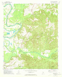
1970 Map of Englewood
USGS Topo · Published 1973About this map
Mound State Mon anchors the southwestern corner of this survey, preserving the archaeological remnants of a pre-colonial Mississippian culture where the Black Warrior River bends through the bottomlands. The landscape transitions from the river's winding course and its associated Fish Hatchery ponds into the rising timberland of the Talladega National Forest to the east. Small agrarian settlements such as Englewood, Maxwell, and Hull are scattered along the Southern railroad line, which served as a primary transit corridor through this part of the Tuscaloosa and Hale County borderlands.
Find a feature on this map
37 named features on this map. Tap any name to fly to it.
Don’t see what you’re looking for? This feature index may not catch every label — zoom into the map to look around manually.
Map Details
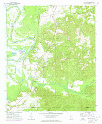
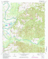
Editions of this 1970 Englewood Map
4 editions found
Historical Maps of Tuscaloosa Through Time
105 maps found

1926 Samantha
Tuscaloosa County, AL

1928 Samantha
Tuscaloosa County, AL

1929 Searles
Tuscaloosa County, AL

1934 Searles
Tuscaloosa County, AL

1949 Wiley
Tuscaloosa County, AL

1951 Wiley
Tuscaloosa County, AL

1967 Berry SE
Tuscaloosa County, AL

1967 Brownville
Tuscaloosa County, AL

1967 Elrod
Tuscaloosa County, AL

1969 Duncanville
Tuscaloosa County, AL

1969 Fosters
Tuscaloosa County, AL

1970 Englewood
Tuscaloosa County, AL

1970 Romulus
Tuscaloosa County, AL

1974 Burchfield Store
Tuscaloosa County, AL

1974 Lake Nicol
Tuscaloosa County, AL

1974 Windham Springs
Tuscaloosa County, AL

1975 Burchfield Store
Tuscaloosa County, AL

1975 Yolande SW
Tuscaloosa County, AL

1978 Gin Creek
Tuscaloosa County, AL

1978 Lake Lurleen
Tuscaloosa County, AL

1978 Lake Tuscaloosa North
Tuscaloosa County, AL

1978 Lake Tuscaloosa South
Tuscaloosa County, AL

1980 Abernant
Tuscaloosa County, AL

2002 Duncanville
Tuscaloosa County, AL

2002 Englewood
Tuscaloosa County, AL

2011 Abernant
Tuscaloosa County, AL

2011 Berry SE
Tuscaloosa County, AL

2011 Brownville
Tuscaloosa County, AL

2011 Burchfield Store
Tuscaloosa County, AL

2011 Duncanville
Tuscaloosa County, AL

2011 Elrod
Tuscaloosa County, AL

2011 Englewood
Tuscaloosa County, AL

2011 Fosters
Tuscaloosa County, AL

2011 Gin Creek
Tuscaloosa County, AL

2011 Lake Lurleen
Tuscaloosa County, AL

2011 Lake Nicol
Tuscaloosa County, AL

2011 Lake Tuscaloosa North
Tuscaloosa County, AL

2011 Lake Tuscaloosa South
Tuscaloosa County, AL

2011 Romulus
Tuscaloosa County, AL

2011 Wiley
Tuscaloosa County, AL

2011 Windham Springs
Tuscaloosa County, AL

2014 Abernant
Tuscaloosa County, AL

2014 Berry SE
Tuscaloosa County, AL

2014 Brownville
Tuscaloosa County, AL

2014 Burchfield Store
Tuscaloosa County, AL

2014 Duncanville
Tuscaloosa County, AL

2014 Elrod
Tuscaloosa County, AL

2014 Englewood
Tuscaloosa County, AL

2014 Fosters
Tuscaloosa County, AL

2014 Gin Creek
Tuscaloosa County, AL

2014 Lake Lurleen
Tuscaloosa County, AL

2014 Lake Nicol
Tuscaloosa County, AL

2014 Lake Tuscaloosa North
Tuscaloosa County, AL

2014 Lake Tuscaloosa South
Tuscaloosa County, AL

2014 Romulus
Tuscaloosa County, AL

2014 Wiley
Tuscaloosa County, AL

2014 Windham Springs
Tuscaloosa County, AL

2018 Abernant
Tuscaloosa County, AL

2018 Berry SE
Tuscaloosa County, AL

2018 Brownville
Tuscaloosa County, AL

2018 Burchfield Store
Tuscaloosa County, AL

2018 Duncanville
Tuscaloosa County, AL

2018 Elrod
Tuscaloosa County, AL

2018 Englewood
Tuscaloosa County, AL

2018 Fosters
Tuscaloosa County, AL

2018 Gin Creek
Tuscaloosa County, AL

2018 Lake Lurleen
Tuscaloosa County, AL

2018 Lake Nicol
Tuscaloosa County, AL

2018 Lake Tuscaloosa North
Tuscaloosa County, AL

2018 Lake Tuscaloosa South
Tuscaloosa County, AL

2018 Romulus
Tuscaloosa County, AL

2018 Wiley
Tuscaloosa County, AL

2018 Windham Springs
Tuscaloosa County, AL

2020 Abernant
Tuscaloosa County, AL

2020 Berry SE
Tuscaloosa County, AL

2020 Brownville
Tuscaloosa County, AL

2020 Burchfield Store
Tuscaloosa County, AL

2020 Elrod
Tuscaloosa County, AL

2020 Fosters
Tuscaloosa County, AL

2020 Gin Creek
Tuscaloosa County, AL

2020 Lake Lurleen
Tuscaloosa County, AL

2020 Lake Nicol
Tuscaloosa County, AL

2020 Lake Tuscaloosa North
Tuscaloosa County, AL

2020 Lake Tuscaloosa South
Tuscaloosa County, AL

2020 Romulus
Tuscaloosa County, AL

2020 Wiley
Tuscaloosa County, AL

2020 Windham Springs
Tuscaloosa County, AL

2021 Duncanville
Tuscaloosa County, AL

2021 Englewood
Tuscaloosa County, AL

2024 Abernant
Tuscaloosa County, AL

2024 Berry SE
Tuscaloosa County, AL

2024 Brownville
Tuscaloosa County, AL

2024 Burchfield Store
Tuscaloosa County, AL

2024 Duncanville
Tuscaloosa County, AL

2024 Elrod
Tuscaloosa County, AL

2024 Englewood
Tuscaloosa County, AL

2024 Fosters
Tuscaloosa County, AL

2024 Gin Creek
Tuscaloosa County, AL

2024 Lake Lurleen
Tuscaloosa County, AL

2024 Lake Nicol
Tuscaloosa County, AL

2024 Lake Tuscaloosa North
Tuscaloosa County, AL

2024 Lake Tuscaloosa South
Tuscaloosa County, AL

2024 Romulus
Tuscaloosa County, AL

2024 Wiley
Tuscaloosa County, AL

2024 Windham Springs
Tuscaloosa County, AL