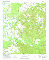
1970 Map of Englewood
USGS Topo · Published 1978About this map
The Black Warrior River defines the western edge of this landscape, its banks marked by the historic McPherson Landing and the expansive Mound State Mon near Moundville. This 1970s survey captures a transition between the river lowlands and the uplands of the Talladega National Forest, where the terrain is punctuated by a dense network of country churches like Zion Hope Ch, Antioch Ch, and Mt Sinai Ch. Small settlements such as Englewood, Hull, and Maxwell are connected by the Southern Railway corridor, which runs parallel to the river valley.
Find a feature on this map
37 named features on this map. Tap any name to fly to it.
Don’t see what you’re looking for? This feature index may not catch every label — zoom into the map to look around manually.
Map Details
Editions of this 1970 Englewood Map
4 editions found
Other maps of this area

1899 · Brookwood
USGS Topo · 1:125,000

1924 · Tuscaloosa
USGS Topo · 1:62,500

1926 · Tuscaloosa
USGS Topo · 1:62,500

1931 · Cottondale
USGS Topo · 1:48,000

1934 · Cottondale
USGS Topo · 1:62,500

1953 · Montgomery
USGS Topo · 1:250,000

1953 · Birmingham
USGS Topo · 1:250,000

1956 · Birmingham
USGS Topo · 1:250,000

1956 · Montgomery
USGS Topo · 1:250,000

1957 · Birmingham
USGS Topo · 1:250,000