1940s Maps of Winston County, Alabama
Explore 9 historic maps of Winston County from the 1940s. These maps offer a rare glimpse into what life looked like during the 1940s — showing old roads, neighborhoods, homes, and landmarks that have changed or disappeared over time.
Whether you're researching your family's past, planning a metal detecting trip, or studying how Winston County's landscape evolved across the 1940s, these high-resolution maps are a powerful tool for exploring the history of this region.
- Focus on a specific era: All maps on this page are from the 1940s, giving you a focused view of this time period.
- See what’s changed: Compare century-old streets, trails, and buildings to today's modern landscape using overlays and satellite layers.
- Research with precision: Use these maps for genealogy, historical research, land use analysis, or educational projects.
- View, download, or print: Maps are fully viewable online in high resolution, and can be downloaded or printed for your own records.
Start exploring Winston County's history through authentic maps from the 1940s. This is your window into the past.
Winston County, AL maps
(9)- 1940 Map of Mt Hope
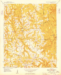
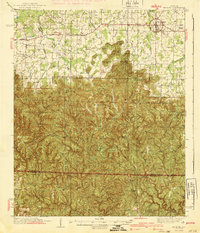 1940 Mt Hope1940 Print · USGSLawrence and Winston counties are captured here in the early 1940s as the Moulton Valley agricultural landscape meets the forest. Researchers can trace family sites at Cave Spring Ch, Heflin Cem, and the depression-era CCC Camp.3 unique versions available
 - 1946 Map of Phil Campbell, 1967 Print
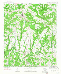 1946 Phil Campbell1967 Print · USGSNorthwestern Alabama in the mid-1940s reveals a landscape defined by the SOUTHERN rail line and deep mining roots. Trace the locations of early rural schools and churches like Phillips High Sch and Shady Grove Ch, or locate old mines and the Donaldson Mill.3 unique versions available
 - 1947 Map of Phil Campbell
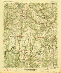 1947 Phil Campbell1947 Print · USGSPhil Campbell and Bear Creek anchor this post-war survey of the Alabama hill country at a time when the Southern railroad still fueled local industry. Researchers can trace rural life through numerous sites like Phillips High Sch, Dime, and the Wilson Mine (Aband).2 unique versions available
 - 1947 Map of Kinlock Spring, 1974 Print
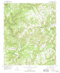
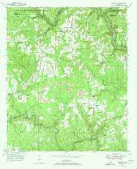
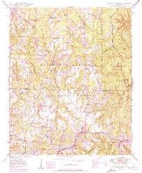 1947 Kinlock Spring1974 Print · USGSWinston County and its surrounding forest lands are captured here during the mid-twentieth century as federal management and rural life intersected. Researchers can locate early schools and churches like Trapptown Sch, Maxwell Chapel, and the site of an abandoned CCC Camp.
 - 1949 Map of Kinlock Spring
 1949 Kinlock Spring1949 Print · USGSIn the late 1940s, this portion of the Bankhead National Forest was a landscape of remote ridges and family settlements. Genealogists can trace rural life through landmarks like Posey Mill, New Bethlehem, and the CCC Camp 931 (Abandoned).
 - 1949 Map of Cold Springs, 1969 Print
 1949 Cold Springs1969 Print · USGSCullman County life in the late 1940s centers on the ridge-top settlements and creek valleys near the Sipsey Fork. Researchers can trace rural lineages through numerous country landmarks like Cold Springs, Drummond Sch, and the Banking Grounds.5 unique versions available
 - 1949 Map of Manchester, 1972 Print
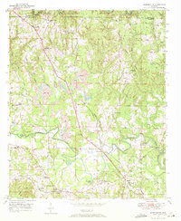 1949 Manchester1972 Print · USGSWalker County during the late 1940s shows a landscape of small mining and farming settlements connected by the Alabama Central Railroad. Genealogists can locate family landmarks like Old Bennett Cem, Macedonia Sch, and the rural community at Five Points.2 unique versions available
 - 1949 Map of Nauvoo, 1973 Print
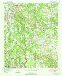 1949 Nauvoo1973 Print · USGSPost-war Walker County comes to life in this detailed survey of the plateau country. Researchers can trace family roots through numerous local landmarks like Keeton Cem, Old Zion Ch, and the rural Nix Sch.2 unique versions available
 - 1949 Map of Sunlight, 1973 Print
 1949 Sunlight1973 Print · USGSWalker County at the end of the 1940s reveals a landscape of winding creek valleys and emerging coal extraction. Researchers can trace family history at sites like Blooming Grove Cem, the settlement of Sunlight, and Philadelphia Ch.3 unique versions available
End of results
Showing maps 1-9 of 9
Top cities of Winston County
- Haleyville historical maps
- Double Springs historical maps
- Lynn historical maps
- Addison historical maps
- Arley historical maps
- Natural Bridge historical maps
Frequently asked questions
- What are the different types of historical maps available for Winston County?
- What is the oldest map of Winston County?
- Where can I purchase historical maps of Winston County for my home or office?
- Where can I download high-res historical maps of Winston County?
- Are there historical topographic maps available for Winston County?
- Is there historical aerial imagery available for Winston County?
- Where are historical maps of Winston County sourced from?