1900s (20th Century) Maps of Tanana Valley, Anchorage
Explore 14 historic maps of Tanana Valley from the 1900s (20th Century). These maps offer a rare glimpse into what life looked like during the 1900s — showing old roads, neighborhoods, homes, and landmarks that have changed or disappeared over time.
Whether you're researching your family's past, planning a metal detecting trip, or studying how Tanana Valley's landscape evolved across the 1900s, these high-resolution maps are a powerful tool for exploring the history of this region.
- Focus on a specific era: All maps on this page are from the 1900s, giving you a focused view of this time period.
- See what’s changed: Compare century-old streets, trails, and buildings to today's modern landscape using overlays and satellite layers.
- Research with precision: Use these maps for genealogy, historical research, land use analysis, or educational projects.
- View, download, or print: Maps are fully viewable online in high resolution, and can be downloaded or printed for your own records.
Start exploring Tanana Valley's history through authentic maps from the 1900s. This is your window into the past.
Tanana Valley, Anchorage maps
(14)- 1949 Map of Tyonek, 1954 Print
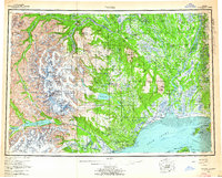
 1949 Tyonek1954 Print · USGSUpper Cook Inlet and the Alaska Range appear here in the mid-twentieth century as a landscape of massive glaciers and river-bound outposts. Researchers can trace the early rail corridor through Willow, locate the Moquawkie Indian Reservation, and find the site of McDougall.2 unique versions available
 - 1951 Map of Anchorage
 1951 Anchorage1951 Print · USGSMid-century Anchorage and the Matanuska Valley are seen here during a period of rapid strategic growth. Trace the development of Fort Richardson, early rail stops at Wasilla, and established mining operations like the Independence Mine or Premier Mine.4 unique versions available
 - 1951 Map of Tyonek
 1951 Tyonek1951 Print · USGSThe Cook Inlet and the Alaska Range come into focus in the early fifties as the region's rail and trail networks evolved. Trace the path of the Alaska Railroad through Willow or locate the historic Iditarod Trail near Susitna.
 - 1951 Map of Tyonek A-1, 1971 Print
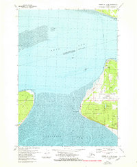
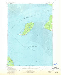 1951 Tyonek A-11971 Print · USGSThe upper Cook Inlet and Fire Island are captured in the early 1950s, showing a critical maritime and military landscape just west of Anchorage. Researchers can locate early aviation markers like the Landing Strip and coastal landmarks such as Fire Island Light and Pt Possession.2 unique versions available
 - 1952 Map of Tyonek A-1, 1954 Print
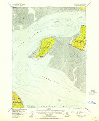 1952 Tyonek A-11954 Print · USGSThe upper Cook Inlet in the early fifties was a landscape of strategic military outposts and essential maritime lights. Genealogists and historians can trace mid-century infrastructure from the Point Campbell ACS Station to the Landing Strip on Fire Island.3 unique versions available
 - 1952 Map of Anchorage A-8, 1963 Print
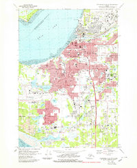
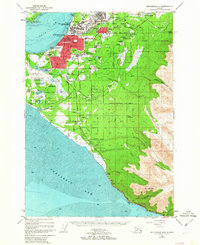 1952 Anchorage A-81963 Print · USGSAnchorage and its surrounding military hubs are shown here during a period of rapid mid-century expansion. Trace the early footprints of Spenard and Mountain View, or locate landmarks like the International Airport and the Alaska Railroad.4 unique versions available
 - 1953 Map of Anchorage A-8, 1954 Print
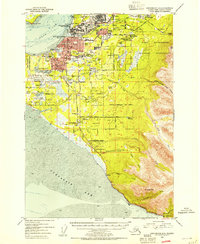 1953 Anchorage A-81954 Print · USGSAnchorage during the early 1950s reveals a city rapidly expanding around its military bases and new aviation hubs. Researchers can trace the development of early neighborhoods like Spenard, the operations of the Alaska Railroad, and local landmarks like the Prison Farm.2 unique versions available
 - 1958 Map of Tyonek, 1964 Print
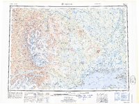
 1958 Tyonek1964 Print · USGSUpper Cook Inlet and the Susitna River valley are shown in the late fifties, capturing a period of transition between coastal village life and inland development. Researchers can trace the Winter Trail and Tractor Trail paths to settlements like Alexander and Susitna.6 unique versions available
 - 1962 Map of Anchorage, 1966 Print
 1962 Anchorage1966 Print · USGSThe Anchorage bowl and Matanuska Valley appear in this mid-century survey during a period of significant military and industrial expansion. Researchers can trace the Alaska Railroad through Sutton and Jonesville or locate historic stops like Meekins Roadhouse and the Watertower Inn.6 unique versions available
 - 1965 Map of Tyonek
 1965 Tyonek1965 Print · USGSUpper Cook Inlet in the mid-sixties reveals a landscape defined by massive glaciers and the early footprints of coastal settlements. Trace the rail-and-river network from The Alaska Railroad to isolated outposts like Old Tyonek, Ladd, and the Moquawkie (Tyonek) Indian Reservation.
 - 1979 Map of Anchorage A-8 NW
 1979 Anchorage A-8 NW1979 Print · USGSAnchorage and its surrounding neighborhoods are shown during a time of major urban expansion in the late seventies. Researchers can trace the layout of early suburbs like Spenard and Turnagain Heights or locate civic landmarks like Merrill Field and Memorial Park.3 unique versions available
 - 1979 Map of Anchorage, 1980 Print
 1979 Anchorage1980 Print · USGSThe Anchorage bowl and Matanuska Valley appear in the late seventies as the region's transportation and military infrastructure matured. Genealogists and historians can trace rail and road evolution through Wasilla, the Matanuska Branch line, and Jonesville.
 - 1979 Map of Tyonek A-1 NE, 1980 Print
 1979 Tyonek A-1 NE1980 Print · USGSThe Anchorage coastline at the close of the 1970s reveals a strategic landscape of aviation and military infrastructure. Researchers can trace the boundaries of the Point Campbell Military Reservation and the early layout of Anchorage International Airport.2 unique versions available
 - 1994 Map of Anchorage A-8, 2002 Print
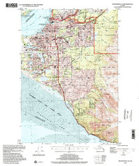 1994 Anchorage A-82002 Print · USGSAnchorage during the mid-nineties shows a city defined by its military bases, university campuses, and bustling aviation hubs. Researchers can trace the development of suburban neighborhoods and major landmarks like the Diamond Center Shopping Mall, Wilson Village, and the Fort Richardson Cem.
End of results
Showing maps 1-14 of 14
Frequently asked questions
- What are the different types of historical maps available for Tanana Valley?
- What is the oldest map of Tanana Valley?
- Where can I purchase historical maps of Tanana Valley for my home or office?
- Where can I download high-res historical maps of Tanana Valley?
- Are there historical topographic maps available for Tanana Valley?
- Is there historical aerial imagery available for Tanana Valley?
- Where are historical maps of Tanana Valley sourced from?