1950s Maps of Summit, Alaska
Explore 6 historic maps of Summit from the 1950s. These maps offer a rare glimpse into what life looked like during the 1950s — showing old roads, neighborhoods, homes, and landmarks that have changed or disappeared over time.
Whether you're researching your family's past, planning a metal detecting trip, or studying how Summit's landscape evolved across the 1950s, these high-resolution maps are a powerful tool for exploring the history of this region.
- Focus on a specific era: All maps on this page are from the 1950s, giving you a focused view of this time period.
- See what’s changed: Compare century-old streets, trails, and buildings to today's modern landscape using overlays and satellite layers.
- Research with precision: Use these maps for genealogy, historical research, land use analysis, or educational projects.
- View, download, or print: Maps are fully viewable online in high resolution, and can be downloaded or printed for your own records.
Start exploring Summit's history through authentic maps from the 1950s. This is your window into the past.
Summit, AK maps
(6)- 1950 Map of Healy B-5, 1974 Print
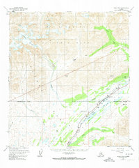 1950 Healy B-51974 Print · USGSThe Alaska Range in the early 1950s served as a vital transit corridor for the interior's developing infrastructure. Researchers can trace the high-altitude route of the Alaska Railroad as it passes through Summit and the CAA Station near Summit Lake.3 unique versions available
 - 1951 Map of Healy
 1951 Healy1951 Print · USGSThe Alaska interior during the early fifties reveals a landscape shaped by the Alaska Railroad and the mining of the Alaska Range. Trace early settlements and infrastructure like Suntrana, the Dunkle Coal Mine, and the McKinley Park Airstrip at the edge of the wilderness.5 unique versions available
 - 1951 Map of Healy B-5, 1952 Print
 1951 Healy B-51952 Print · USGSThe Alaska interior at the dawn of the fifties reveals a landscape defined by the Alaska Railroad and the high Alaska Range. Trace the rail infrastructure at Summit, including the Airstrip, Water Tank, and the remote Mile 315 marker.2 unique versions available
 - 1953 Map of Healy B-5, 1957 Print
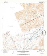
 1953 Healy B-51957 Print · USGSThe Alaska Range interior is captured here in the early 1950s as the rail line climbs toward the park boundary. Researchers can trace the steam-era infrastructure of the Alaska Railroad through remote stops like Summit, Edee, and Mile 311.
 - 1956 Map of Healy B-5, 1963 Print
 1956 Healy B-51963 Print · USGSThe Alaska Range and the high passes of the interior are captured here in the 1950s, showing the intersection of wilderness and vital transport. Trace the path of the Alaska Railroad as it passes Summit Lake, the CAA Station, and the remote Airstrip.
 - 1956 Map of Healy, 1966 Print
 1956 Healy1966 Print · USGSThe interior of Alaska is shown during a period of industrial and recreational expansion in the mid-fifties. Genealogists and historians can trace the Alaska Railroad corridor through Healy and mining sites like Usibelli Mine.4 unique versions available
End of results
Showing maps 1-6 of 6
Frequently asked questions
- What are the different types of historical maps available for Summit?
- What is the oldest map of Summit?
- Where can I purchase historical maps of Summit for my home or office?
- Where can I download high-res historical maps of Summit?
- Are there historical topographic maps available for Summit?
- Is there historical aerial imagery available for Summit?
- Where are historical maps of Summit sourced from?