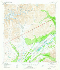
1956 Map of Healy B-5
USGS Topo · Published 1963About this map
Mt McKinley National Park dominates the northern half of this mid-century survey, with its National Park Boundary cutting diagonally across the high terrain of the Alaska Range. The landscape is defined by the massive Cantwell Glacier and the high point of Foggy Pass, which separates the northern drainages from the southern river systems. This era of the Alaskan interior is characterized by the critical infrastructure of the Alaska Railroad, which snakes through the mountain passes alongside an Airstrip and a CAA Station near Summit Lake. The map reveals a transition from the glacial heights to the braided waters of the Middle Fork Chulitna River and Bull River, showing the importance of transportation corridors in this mountain environment during the 1950s. Survey points like VABM 2235 Trestle and Water Tank indicate the technical demands of maintaining a rail line through such a dynamic wilderness.
Find a feature on this map
27 named features on this map. Tap any name to fly to it.
Don’t see what you’re looking for? This feature index may not catch every label — zoom into the map to look around manually.
Map Details
Editions of this 1956 Healy B-5 Map
This is the sole edition of this map. No revisions or reprints were ever made.
Other maps of this area

1949 · Healy B-4
USGS Topo · 1:63,360

1949 · Healy A-6
USGS Topo · 1:63,360

1950 · Healy C-4
USGS Topo · 1:63,360

1950 · Healy A-4
USGS Topo · 1:63,360

1950 · Healy A-5
USGS Topo · 1:63,360

1950 · Healy B-5
USGS Topo · 1:63,360

1951 · Healy
USGS Topo · 1:250,000

1951 · Healy B-5
USGS Topo · 1:63,360

1951 · Healy B-4
USGS Topo · 1:63,360

1952 · Healy C-5
USGS Topo · 1:63,360