
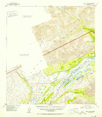
1951 Map of Healy B-5
USGS Topo · Published 1952About this map
The Alaska Railroad cuts a precise line through the Alaska Range in this 1951 survey, following the corridor of the Middle Fork Chulitna River toward the interior. This high-mountain landscape is dominated by the transition from the McKinley Range and includes the National Park Boundary as it was defined in the mid-century. High-altitude landmarks like Foggy Pass and the drainage of Windy Creek highlight the difficult terrain surveyors faced.
Find a feature on this map
32 named features on this map. Tap any name to fly to it.
Don’t see what you’re looking for? This feature index may not catch every label — zoom into the map to look around manually.
Map Details
Editions of this 1951 Healy B-5 Map
2 editions found
Other maps of this area

1949 · Healy B-4
USGS Topo · 1:63,360

1949 · Healy A-6
USGS Topo · 1:63,360

1950 · Healy C-4
USGS Topo · 1:63,360

1950 · Healy A-4
USGS Topo · 1:63,360

1950 · Healy A-5
USGS Topo · 1:63,360

1950 · Healy B-5
USGS Topo · 1:63,360

1951 · Healy
USGS Topo · 1:250,000

1951 · Healy B-4
USGS Topo · 1:63,360

1952 · Healy C-5
USGS Topo · 1:63,360

1952 · Healy A-4
USGS Topo · 1:63,360