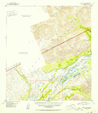
1951 Map of Healy B-5
USGS Topo · Published 1952About this map
The Alaska Railroad serves as the primary artery through this high-altitude landscape, tracing a route through the Alaska Range during the early 1950s. The settlement of Summit marks a critical point on the line, accompanied by infrastructure such as a Water Tank, a Tank, and a nearby Airstrip. This corridor follows the drainage of Cantwell Creek before crossing the National Park Boundary and descending toward the drainage of the Middle Fork Chulitna River.
Find a feature on this map
28 named features on this map. Tap any name to fly to it.
Don’t see what you’re looking for? This feature index may not catch every label — zoom into the map to look around manually.
Map Details
Editions of this 1951 Healy B-5 Map
2 editions found
Other maps of this area

1949 · Healy B-4
USGS Topo · 1:63,360

1949 · Healy A-6
USGS Topo · 1:63,360

1950 · Healy C-4
USGS Topo · 1:63,360

1950 · Healy A-4
USGS Topo · 1:63,360

1950 · Healy A-5
USGS Topo · 1:63,360

1950 · Healy B-5
USGS Topo · 1:63,360

1951 · Healy
USGS Topo · 1:250,000

1951 · Healy B-5
USGS Topo · 1:63,360

1951 · Healy B-4
USGS Topo · 1:63,360

1952 · Healy C-5
USGS Topo · 1:63,360