
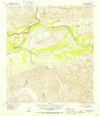
1951 Map of Healy B-4
USGS Topo · Published 1952About this map
The Alaska Railroad cuts a narrow path through the eastern flank of the Alaska Range in the early 1950s, following the Nenana River and establishing a vital corridor for interior travel. The settlement of Cantwell serves as a key transit point, featuring the Cantwell Airstrip and a Water Tank for steam-era railway operations. This survey documents the intersection of industrial infrastructure and the preservation of the Mt McKinley National Park, whose eastern boundary is clearly delineated. To the north, the terrain transitions into the high peaks of Panorama Mountain and the Reindeer Hills. The map also captures several local transport routes, including The Tractor Trail near the Windy station, and marks the hydrological divide where the Jack River and the Middle Fork Chulitna River diverge toward separate drainage systems.
Find a feature on this map
28 named features on this map. Tap any name to fly to it.
Don’t see what you’re looking for? This feature index may not catch every label — zoom into the map to look around manually.
Map Details
Editions of this 1951 Healy B-4 Map
2 editions found
Other maps of this area

1949 · Healy B-4
USGS Topo · 1:63,360

1949 · Healy C-3
USGS Topo · 1:63,360

1950 · Healy C-4
USGS Topo · 1:63,360

1950 · Healy A-3
USGS Topo · 1:63,360

1950 · Healy B-3
USGS Topo · 1:63,360

1950 · Healy A-4
USGS Topo · 1:63,360

1950 · Healy A-5
USGS Topo · 1:63,360

1950 · Healy B-5
USGS Topo · 1:63,360

1951 · Healy
USGS Topo · 1:250,000

1951 · Healy B-5
USGS Topo · 1:63,360