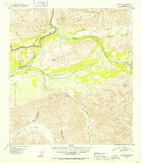
1951 Map of Healy B-4
USGS Topo · Published 1952About this map
The Alaska Railroad serves as a critical transportation artery through this corridor of the Alaska Range, following the winding path of the Nenana River. This 1949 aerial survey shows the settlement of Cantwell as a focal point for the region, featuring a Water Tank and the Cantwell Airstrip located just outside the eastern boundary of Mt McKinley National Park. The landscape is defined by the significant elevation of the Reindeer Hills and Panorama Mountain, while lower-lying routes like The Tractor Trail provide access through the valley floor. To the south, the Jack River and Chulitna River systems drain the high peaks, marked by remote landmarks such as Caribou Pass. The map captures a moment when infrastructure was closely tied to the railroad and basic air facilities, centered on these small mountain outposts.
Find a feature on this map
34 named features on this map. Tap any name to fly to it.
Don’t see what you’re looking for? This feature index may not catch every label — zoom into the map to look around manually.
Map Details
Editions of this 1951 Healy B-4 Map
2 editions found

Other maps of this area

1949 · Healy B-4
USGS Topo · 1:63,360

1949 · Healy C-3
USGS Topo · 1:63,360

1950 · Healy C-4
USGS Topo · 1:63,360

1950 · Healy A-3
USGS Topo · 1:63,360

1950 · Healy B-3
USGS Topo · 1:63,360

1950 · Healy A-4
USGS Topo · 1:63,360

1950 · Healy A-5
USGS Topo · 1:63,360

1950 · Healy B-5
USGS Topo · 1:63,360

1951 · Healy
USGS Topo · 1:250,000

1951 · Healy B-5
USGS Topo · 1:63,360