Old Maps of Summit, Alaska for Academic Research
Study the evolution of Summit with 8 high-resolution historic maps. Whether you're teaching, researching, or modeling changes in land use, these maps provide essential visual documentation of urban, environmental, and geographic change.
- Analyze long-term change: Track patterns in development, transportation, and natural features.
- Ideal for environmental or urban studies: Support academic projects with primary historical map data.
- Use in the classroom or lab: Educators and researchers rely on these maps to bring historical context to life.
These maps are a powerful tool for teaching, research, and visualizing how Summit has changed over the decades.
Summit, AK maps
(8)- 1950 Map of Healy B-5, 1974 Print
 1950 Healy B-51974 Print · USGSThe Alaska Range in the early 1950s served as a vital transit corridor for the interior's developing infrastructure. Researchers can trace the high-altitude route of the Alaska Railroad as it passes through Summit and the CAA Station near Summit Lake.3 unique versions available
 - 1951 Map of Healy
 1951 Healy1951 Print · USGSThe Alaska interior during the early fifties reveals a landscape shaped by the Alaska Railroad and the mining of the Alaska Range. Trace early settlements and infrastructure like Suntrana, the Dunkle Coal Mine, and the McKinley Park Airstrip at the edge of the wilderness.5 unique versions available
 - 1951 Map of Healy B-5, 1952 Print
 1951 Healy B-51952 Print · USGSThe Alaska interior at the dawn of the fifties reveals a landscape defined by the Alaska Railroad and the high Alaska Range. Trace the rail infrastructure at Summit, including the Airstrip, Water Tank, and the remote Mile 315 marker.2 unique versions available
 - 1953 Map of Healy B-5, 1957 Print
 1953 Healy B-51957 Print · USGSThe Alaska Range interior is captured here in the early 1950s as the rail line climbs toward the park boundary. Researchers can trace the steam-era infrastructure of the Alaska Railroad through remote stops like Summit, Edee, and Mile 311.
 - 1956 Map of Healy B-5, 1963 Print
 1956 Healy B-51963 Print · USGSThe Alaska Range and the high passes of the interior are captured here in the 1950s, showing the intersection of wilderness and vital transport. Trace the path of the Alaska Railroad as it passes Summit Lake, the CAA Station, and the remote Airstrip.
 - 1956 Map of Healy, 1966 Print
 1956 Healy1966 Print · USGSThe interior of Alaska is shown during a period of industrial and recreational expansion in the mid-fifties. Genealogists and historians can trace the Alaska Railroad corridor through Healy and mining sites like Usibelli Mine.4 unique versions available
 - 2016 Map of Healy B-5 SE, 2016 Print
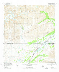
 2016 Healy B-5 SE2016 Print · USGSCovers Summit, including Matanuska-Susitna, Denali, and other nearby areas
 - 2024 Map of Healy B-5 SE, 2024 Print
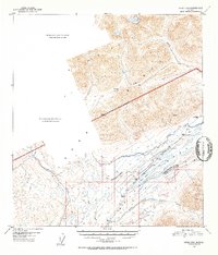
 2024 Healy B-5 SE2024 Print · USGSBroad Pass and the interior Alaska Range are captured in this contemporary survey of the high mountain corridor. Researchers can trace the infrastructure of Cantwell and Summit along the Parks Highway near Summit Lake and Summit Airport.
End of results
Showing maps 1-8 of 8
Frequently asked questions
- What are the different types of historical maps available for Summit?
- What is the oldest map of Summit?
- Where can I purchase historical maps of Summit for my home or office?
- Where can I download high-res historical maps of Summit?
- Are there historical topographic maps available for Summit?
- Is there historical aerial imagery available for Summit?
- Where are historical maps of Summit sourced from?