1960s Maps of Totem Park, Alaska
Explore 3 historic maps of Totem Park from the 1960s. These maps offer a rare glimpse into what life looked like during the 1960s — showing old roads, neighborhoods, homes, and landmarks that have changed or disappeared over time.
Whether you're researching your family's past, planning a metal detecting trip, or studying how Totem Park's landscape evolved across the 1960s, these high-resolution maps are a powerful tool for exploring the history of this region.
- Focus on a specific era: All maps on this page are from the 1960s, giving you a focused view of this time period.
- See what’s changed: Compare century-old streets, trails, and buildings to today's modern landscape using overlays and satellite layers.
- Research with precision: Use these maps for genealogy, historical research, land use analysis, or educational projects.
- View, download, or print: Maps are fully viewable online in high resolution, and can be downloaded or printed for your own records.
Start exploring Totem Park's history through authentic maps from the 1960s. This is your window into the past.
Totem Park, AK maps
(3)- 1964 Map of Fairbanks
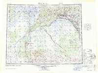 1964 Fairbanks1964 Print · USGSInterior Alaska in the mid-1960s centered on the growing hub of Fairbanks and its strategic military and rail connections. Genealogists and historians can trace the paths of The Alaska Railroad through Nenana or locate Placer Mines near Murphy Dome and Ester.
 - 1965 Map of Fairbanks D-2, 1966 Print
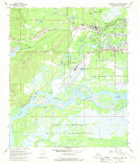
 1965 Fairbanks D-21966 Print · USGSMid-century Fairbanks and its growing suburbs are captured here as the interior infrastructure of Alaska modernized. Genealogists and historians can trace the early footprints of College, Dogpatch, and Fort Wainwright alongside the sprawling TANANA RIVER.
 - 1966 Map of Fairbanks D-2 SW, 1970 Print
 1966 Fairbanks D-2 SW1970 Print · USGSFairbanks and its surrounding river valleys come alive in the mid-sixties as the university and military base expand. Trace the industrial landscape of Dredge Tailings and the Alaska Railroad alongside settlements at College and Ester Crossing.2 unique versions available
End of results
Showing maps 1-3 of 3
Top cities near Totem Park
Frequently asked questions
- What are the different types of historical maps available for Totem Park?
- What is the oldest map of Totem Park?
- Where can I purchase historical maps of Totem Park for my home or office?
- Where can I download high-res historical maps of Totem Park?
- Are there historical topographic maps available for Totem Park?
- Is there historical aerial imagery available for Totem Park?
- Where are historical maps of Totem Park sourced from?