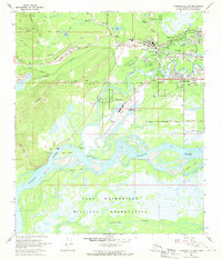
1966 Map of Fairbanks D-2 SW
USGS Topo · Published 1970About this map
The University of Alaska campus and the sprawling Fort Wainwright Military Reservation anchor this mid-1960s study of the Interior's largest hub. The landscape is defined by the complex hydrology of the Tanana River and Chena River, where braided channels create significant landforms like Byers Island and Wenrich Island. The intersection of heavy industry and civil infrastructure is evident in the Dredge Tailings near Gold Hill and the extensive tracks of the Alaska Railroad serving the heart of Fairbanks. This era shows a community in transition, with established neighborhoods like College and Broadmoor expanding alongside the critical aviation facilities at Fairbanks International Airport and the smaller Metro Field.
Find a feature on this map
56 named features on this map. Tap any name to fly to it.
Don’t see what you’re looking for? This feature index may not catch every label — zoom into the map to look around manually.
Map Details
Editions of this 1966 Fairbanks D-2 SW Map
2 editions found
Other maps of this area

1949 · Fairbanks D-2
USGS Topo · 1:62,500

1949 · Fairbanks D-3
USGS Topo · 1:63,360

1949 · Fairbanks C-2
USGS Topo · 1:63,360

1950 · Fairbanks
USGS Topo · 1:250,000

1950 · Fairbanks C-3
USGS Topo · 1:63,360

1950 · Fairbanks D-3
USGS Topo · 1:63,360

1951 · Fairbanks
USGS Topo · 1:250,000

1952 · Fairbanks C-2
USGS Topo · 1:63,360

1952 · Fairbanks D-2
USGS Topo · 1:63,360

1952 · Fairbanks D-3
USGS Topo · 1:63,360