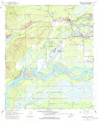
1966 Map of Fairbanks D-2 SW
USGS Topo · Published 1975About this map
The Tanana River and Chenna River dominate this mid-1960s landscape, illustrating the complex hydrology surrounding the city of Fairbanks. Significant portions of the terrain are shaped by industrial mining history, specifically visible in the extensive Dredge Tailings north of Chena Ridge. The integration of transportation and education is evident as the Alaska Railroad skirts the southern edge of the University of Alaska campus near College. Urban development is concentrated around several sloughs and aviation hubs, including the Fairbanks International Airport and Metro Field. To the south, the expansive Fort Wainwright Military Reservation occupies the flatlands between the major river systems, while neighborhood growth is noted in areas like Aurora and Broadmoor.
Find a feature on this map
47 named features on this map. Tap any name to fly to it.
Don’t see what you’re looking for? This feature index may not catch every label — zoom into the map to look around manually.
Map Details
Editions of this 1966 Fairbanks D-2 SW Map
2 editions found
Other maps of this area

1949 · Fairbanks D-2
USGS Topo · 1:62,500

1949 · Fairbanks D-3
USGS Topo · 1:63,360

1949 · Fairbanks C-2
USGS Topo · 1:63,360

1950 · Fairbanks
USGS Topo · 1:250,000

1950 · Fairbanks C-3
USGS Topo · 1:63,360

1950 · Fairbanks D-3
USGS Topo · 1:63,360

1951 · Fairbanks
USGS Topo · 1:250,000

1952 · Fairbanks C-2
USGS Topo · 1:63,360

1952 · Fairbanks D-2
USGS Topo · 1:63,360

1952 · Fairbanks D-3
USGS Topo · 1:63,360