Old Maps of Homer, Alaska for Genealogy
Trace your family roots with 20 historic maps of Homer. These high-res maps reveal old neighborhoods, homesites, landmarks, and streets — helping you uncover where your ancestors lived and how the area evolved over time.
- Explore historic neighborhoods: Identify where your relatives may have lived in the 1800s or 1900s.
- Compare maps over time: Trace the changes in streets, buildings, and landmarks for multi-generational research.
- Perfect for genealogy & ancestry research: Used by family historians and researchers to map out lineage and migration.
These maps are an incredible resource for exploring your personal connection to Homer's past.
Homer, AK maps
(20)- 1946 Map of Seldovia C-5, 1958 Print
 1946 Seldovia C-51958 Print · USGSThe coastal settlement of Homer and the lower Kenai Peninsula are captured here just after the war as the regional road network began to solidify. Researchers can trace early infrastructure like the Sterling Highway, a shoreline Coal Mine, and the Seaplane Anchorage.
 - 1948 Map of Seldovia C-4, 1955 Print
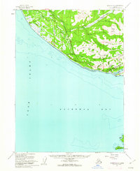
 1948 Seldovia C-41955 Print · USGSThe Kachemak Bay coastline comes alive in the mid-1940s, showing the early infrastructure of the Homer area before its modern expansion. Genealogists and researchers can locate old landmarks like Millers Landing, the original Homer Airport, and the Sawmill along the waterfront.2 unique versions available
 - 1949 Map of Seldovia C-4
 1949 Seldovia C-41949 Print · USGSKachemak Bay and the Kenai Peninsula shoreline are captured here in the late 1940s, showing early maritime and aviation development. Trace the origins of local industry and navigation at Millers Landing, the Homer Spit, and the Homer Airport.
 - 1951 Map of Seldovia C-5
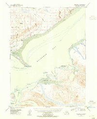
 1951 Seldovia C-51951 Print · USGSThe Kenai Peninsula shoreline comes to life in the early fifties as the southern road system reached toward the sea. Trace the early layout of Homer, the coastal Coal Mine, and landmarks like Ohlson Mtn and Diamond Gulch.
 - 1951 Map of Seldovia, 1952 Print
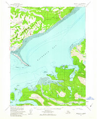
 1951 Seldovia1952 Print · USGSThe lower Kenai Peninsula appears here in the early fifties as a network of coastal outposts and maritime landing sites. Researchers can trace early settlements like Seldovia, locate family-named points such as Millers Landing, and explore the limits of the Kenai National Moose Range.8 unique versions available
 - 1961 Map of Seldovia C-5, 1962 Print
 1961 Seldovia C-51962 Print · USGSThe Kenai Peninsula shoreline and the burgeoning community of Homer are detailed in the early 1960s. Genealogists and historians can trace early neighborhood roads like Skyline Drive and find local landmarks including Lofgren and the Anchor River Campground.4 unique versions available
 - 1961 Map of Seldovia C-4, 1962 Print
 1961 Seldovia C-41962 Print · USGSThe Kenai Peninsula shoreline and the waters of Kachemak Bay come into sharp focus in the early sixties. You can trace the development of Homer and the Homer Spit, or locate isolated landmarks like the Lighthouse near Halibut Cove.3 unique versions available
 - 1963 Map of Seldovia, 1967 Print
 1963 Seldovia1967 Print · USGSThe lower Kenai Peninsula in the 1960s reveals a rugged coastal frontier where the highway finally meets the sea at Homer. Researchers can trace old settlements and family sites at Happy Valley, Stariski, and the Indian Village near Seldovia.5 unique versions available
 - 1987 Map of Seldovia C-5 NE
 1987 Seldovia C-5 NE1987 Print · USGSThe Kenai Peninsula community of Homer is shown during a period of steady growth in the 1980s, perched between the heights of Diamond Ridge and the waters of Kachemak Bay. Researchers can trace the town's infrastructure from the Radio Tower KBBI to the Beluga Lake seaplane dock and local Cem sites.
 - 1987 Map of Seldovia C-4 SW
 1987 Seldovia C-4 SW1987 Print · USGSThe coastal waters and islands of the Kenai Peninsula are documented here in the late twentieth century, showing the extension of Homer Spit into Kachemak Bay. Researchers can trace maritime landmarks from Coal Point to Yukon Island and the wilderness boundaries of Kachemak Bay State Park.
 - 1987 Map of Seldovia C-4 NW
 1987 Seldovia C-4 NW1987 Print · USGSThe Kenai Peninsula coastline near Homer in the late 1980s shows a community balanced between its maritime roots and highland ridges. Researchers can trace the development of Kachemak City, locate the Municipal Airport, and follow the winding path of Skyline Drive.
 - 1987 Map of Seldovia C-5 SE
 1987 Seldovia C-5 SE1987 Print · USGSCoastal waters and isolated islands of the Kenai Peninsula are captured here in the late 1980s. Maritime researchers can trace the shorelines of Yukon Island and Hesketh Island or find the offshore Homer Corporate Boundary within Kachemak Bay.
 - 2018 Map of Seldovia C-4 SW, 2018 Print
 2018 Seldovia C-4 SW2018 Print · USGSCovers Homer, including Kenai Peninsula, United States, and other nearby areas
 - 2018 Map of Seldovia C-4 NW, 2018 Print
 2018 Seldovia C-4 NW2018 Print · USGSCovers Homer, including Kachemak City, Kachemak City, and other nearby areas
 - 2018 Map of Seldovia C-5 NE, 2018 Print
 2018 Seldovia C-5 NE2018 Print · USGSCovers Homer, including Diamond Ridge, Kenai Peninsula, and other nearby areas
 - 2018 Map of Seldovia C-5 SE, 2018 Print
 2018 Seldovia C-5 SE2018 Print · USGSCovers Homer, including Kenai Peninsula, United States, and other nearby areas
 - 2024 Map of Seldovia C-5 SE, 2024 Print
 2024 Seldovia C-5 SE2024 Print · USGSCoastal waters and rugged island outcroppings define the entrance to Kachemak Bay in this recent survey. Researchers can trace the boundaries of the Alaska Maritime National Wildlife Refuge across Yukon Island and Hesketh Island.
 - 2024 Map of Seldovia C-4 NW, 2024 Print
 2024 Seldovia C-4 NW2024 Print · USGSThe Kenai Peninsula coastline near Kachemak Bay is shown here in its modern configuration, where the shoreline meets the rising interior ridges. Genealogists and local researchers can trace the roads and homesteads near Diamond Ridge, Kachemak City, and the prominent Homer Spit.
 - 2024 Map of Seldovia C-5 NE, 2024 Print
 2024 Seldovia C-5 NE2024 Print · USGSThe Kenai Peninsula coastline comes into focus in this contemporary survey of the area between Homer and Anchor Point. Researchers can trace local development through modern street networks and find essential family history landmarks like the Homer Community Cem and Hickerson Memorial Cem.
 - 2024 Map of Seldovia C-4 SW, 2024 Print
 2024 Seldovia C-4 SW2024 Print · USGSKachemak Bay and the Kenai Peninsula shoreline are captured here in the early twenty-first century, showing the transition from the docks of Homer to the wild reaches of the southern coast. Trace maritime landmarks like Homer Spit and island trails such as the Grace Ridge Trl.
End of results
Showing maps 1-20 of 20
Top cities near Homer
Top neighborhoods of Homer
- Kachemak City historical maps
- Homer Spit historical maps
- Quiet Creek historical maps
- Old Town historical maps
Frequently asked questions
- What are the different types of historical maps available for Homer?
- What is the oldest map of Homer?
- Where can I purchase historical maps of Homer for my home or office?
- Where can I download high-res historical maps of Homer?
- Are there historical topographic maps available for Homer?
- Is there historical aerial imagery available for Homer?
- Where are historical maps of Homer sourced from?