Old Maps of Sunrise, Alaska for Academic Research
Study the evolution of Sunrise with 9 high-resolution historic maps. Whether you're teaching, researching, or modeling changes in land use, these maps provide essential visual documentation of urban, environmental, and geographic change.
- Analyze long-term change: Track patterns in development, transportation, and natural features.
- Ideal for environmental or urban studies: Support academic projects with primary historical map data.
- Use in the classroom or lab: Educators and researchers rely on these maps to bring historical context to life.
These maps are a powerful tool for teaching, research, and visualizing how Sunrise has changed over the decades.
Sunrise, AK maps
(9)- 1951 Map of Seward
 1951 Seward1951 Print · USGSThe Kenai Peninsula and Prince William Sound come to life in the early 1950s as the rail and maritime networks linked remote coastal outposts. Genealogists and historians can trace the Alaska Railroad corridor through Seward, find the Jesse Lee Indian School, and locate isolated camps like Latouche and Chenega.4 unique versions available
 - 1951 Map of Seward D-7, 1968 Print
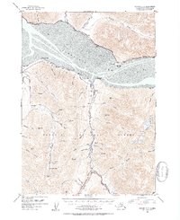
 1951 Seward D-71968 Print · USGSThe northern Kenai Peninsula comes into focus in the early fifties as mining operations and transportation routes defined the rugged interior. Genealogists and historians can trace the foundations of Sunrise and Swetmann Camp or locate the Connolly Mine and Hope Cem.3 unique versions available
 - 1952 Map of Seward D-7, 1954 Print
 1952 Seward D-71954 Print · USGSThe Kenai Peninsula coastline and its inland mining camps are captured here just after the war, showing the vital transit corridor along the northern shore. Genealogists and historians can locate old burial sites like Sunrise Cemetery and trace the paths to early mining operations such as Swetmann Mine and Downing Mine.3 unique versions available
 - 1953 Map of Seward, 1956 Print
 1953 Seward1956 Print · USGSThe Kenai Peninsula and Prince William Sound are documented in the early 1950s as the rail and road networks expanded. Trace the route of the Alaska Railroad and find early settlements like Seward, Moose Pass, and Latouche.12 unique versions available
 - 1959 Map of Seward
 1959 Seward1959 Print · USGSThe Kenai Peninsula and Prince William Sound are captured here during the mid-century, showing the vital transit corridor between Seward and the interior. Researchers can trace the Alaska Railroad through Whittier and locate historic coastal settlements like Chenega and Latouche.
 - 1984 Map of Seward D-7 NE
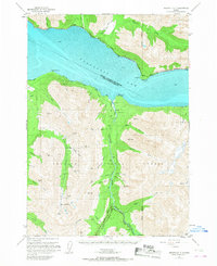
 1984 Seward D-7 NE1984 Print · USGSThe Turnagain Arm shoreline near Anchorage and the Kenai Peninsula is captured here in the mid-eighties. Researchers can locate the settlement of Sunrise near Sixmile Creek or trace coastal features like Bird Point and Snipers Point.
 - 1994 Map of Seward D-7, 1998 Print
 1994 Seward D-71998 Print · USGSThe Kenai Peninsula coastline meets the Chugach Mountains in the mid-1990s as the region's mining and maritime history remains etched into the land. Genealogists and historians can locate legacy sites like Sunrise Cemetery, Swetmann Camp, and the Connolly Mine.
 - 2017 Map of Seward D-7 NE, 2017 Print
 2017 Seward D-7 NE2017 Print · USGSCovers Sunrise, including Kenai Peninsula, Anchorage, and other nearby areas
 - 2023 Map of Seward D-7 NE, 2023 Print
 2023 Seward D-7 NE2023 Print · USGSThe Kenai Peninsula coastline meets the Chugach Mountains in this recent survey of the Turnagain Arm. Genealogists and hikers can trace the settlement of Sunrise, locate the Sunrise Cem, and follow the path of the Seward Highway past Bird Point.
End of results
Showing maps 1-9 of 9
Top cities near Sunrise
Frequently asked questions
- What are the different types of historical maps available for Sunrise?
- What is the oldest map of Sunrise?
- Where can I purchase historical maps of Sunrise for my home or office?
- Where can I download high-res historical maps of Sunrise?
- Are there historical topographic maps available for Sunrise?
- Is there historical aerial imagery available for Sunrise?
- Where are historical maps of Sunrise sourced from?