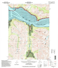
1994 Map of Seward D-7
USGS Topo · Published 1998About this map
Turnagain Arm dominates this northern Kenai Peninsula landscape, where the waters divide the Municipality of Anchorage from the Kenai Peninsula Borough. In the south, the gold mining legacy of the district is evident through a dense concentration of historical workings, including the Nearhouse Mine, Sunshine Mine, and Brushy Ray Mine. The small settlements of Sunrise and Indian anchor the northern and southern shores, connected by the Seward Highway which traces the coastline.
Find a feature on this map
69 named features on this map. Tap any name to fly to it.
Don’t see what you’re looking for? This feature index may not catch every label — zoom into the map to look around manually.
Map Details
Editions of this 1994 Seward D-7 Map
This is the sole edition of this map. No revisions or reprints were ever made.
Other maps of this area

1951 · Seward
USGS Topo · 1:250,000

1951 · Anchorage
USGS Topo · 1:250,000

1951 · Seward C-6
USGS Topo · 1:63,360

1951 · Seward C-8
USGS Topo · 1:63,360

1951 · Seward D-8
USGS Topo · 1:63,360

1951 · Seward D-7
USGS Topo · 1:63,360

1951 · Seward C-7
USGS Topo · 1:63,360

1951 · Seward D-6
USGS Topo · 1:63,360

1952 · Seward C-6
USGS Topo · 1:63,360

1952 · Seward D-8
USGS Topo · 1:63,360