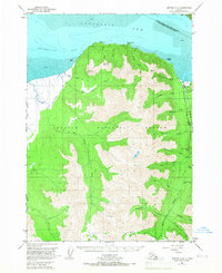
1951 Map of Seward D-8
USGS Topo · Published 1967About this map
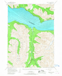
The town of Hope anchors the northeastern corner of this 1950s landscape, situated where Resurrection Creek meets the waters of Turnagain Arm. As a coastal outpost within the Chugach National Forest, the area's economy is defined by its geological riches and maritime proximity. Mining activity is evident through the Robinson-Bowman Mine and Pearson Mine, both located along the drainage of Resurrection Creek.
Find a feature on this map
31 named features on this map. Tap any name to fly to it.
Don’t see what you’re looking for? This feature index may not catch every label — zoom into the map to look around manually.
Map Details
Editions of this 1951 Seward D-8 Map
2 editions found

Other maps of this area

1944 · Kenai
USGS Topo · 1:250,000

1949 · Tyonek
USGS Topo · 1:250,000

1950 · Kenai
USGS Topo · 1:250,000

1951 · Seward
USGS Topo · 1:250,000

1951 · Anchorage
USGS Topo · 1:250,000

1951 · Tyonek
USGS Topo · 1:250,000
1951 · Kenai C-1
USGS Topo · 1:63,360
1951 · Kenai D-1
USGS Topo · 1:63,360
1951 · Seward C-8
USGS Topo · 1:63,360
1951 · Seward D-7
USGS Topo · 1:63,360