
1951 Map of Kenai C-1
USGS Topo · Published 1960About this map
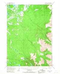
The Kenai National Moose Range dominates this mid-century landscape, capturing a moment of wilderness transition on the Kenai Peninsula. The survey reveals a terrain defined by the complex hydrology of the Chickaloon River and the braided drainage of Mystery Creek. While much of the land is preserved within the Chugach National Forest, human presence is marked by the path of the Sterling Highway and a remote Cabin in the northern reaches. This 1950s data, updated with minor 1960 revisions, shows a region where modern transportation began to intersect with established wildlife habitats. Notable water bodies such as Jean Lake and Hidden L sit near the highway corridor, while a dedicated Snowmobile Trail highlights the importance of winter access in this subarctic environment. The presence of Round Mountain provides a significant topographic anchor in the eastern portion of the quadrangle.
Find a feature on this map
14 named features on this map. Tap any name to fly to it.
Don’t see what you’re looking for? This feature index may not catch every label — zoom into the map to look around manually.
Map Details
Editions of this 1951 Kenai C-1 Map
2 editions found
Other maps of this area

1944 · Kenai
USGS Topo · 1:250,000

1950 · Kenai
USGS Topo · 1:250,000

1950 · Kenai B-1
USGS Topo · 1:63,360

1951 · Seward
USGS Topo · 1:250,000

1951 · Kenai B-2
USGS Topo · 1:63,360

1951 · Kenai C-2
USGS Topo · 1:63,360

1951 · Kenai D-1
USGS Topo · 1:63,360

1951 · Kenai D-2
USGS Topo · 1:63,360

1951 · Seward C-8
USGS Topo · 1:63,360

1951 · Seward D-8
USGS Topo · 1:63,360