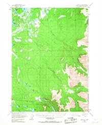
1951 Map of Kenai C-1
USGS Topo · Published 1967About this map
The Kenai National Moose Range dominates this mid-century landscape on the Kenai Peninsula, showcasing a vast network of glacial lakes and waterways before intensive modern development. The Sterling Highway serves as the primary artery through the southern portion of the sheet, providing access to remote features like Upper Jean Lake and Dogteam Lake. This 1951 field-annotated survey captures the era when back-country travel relied on the Ski-Mobile Trail and the Seven Lakes Trail, reflecting a transition towards managed recreation and conservation within the territory. The presence of a Landing Strip near the confluence of Mystery Creek and the Chickaloon River underscores the importance of bush aviation for accessing these interior wetlands. From the peak of Round Mountain to the shores of Rabbit Foot Lake, the map records a wilderness defined by its intricate drainage patterns and early forest management boundaries.
Find a feature on this map
28 named features on this map. Tap any name to fly to it.
Don’t see what you’re looking for? This feature index may not catch every label — zoom into the map to look around manually.
Map Details
Editions of this 1951 Kenai C-1 Map
2 editions found
Other maps of this area

1944 · Kenai
USGS Topo · 1:250,000

1950 · Kenai
USGS Topo · 1:250,000

1950 · Kenai B-1
USGS Topo · 1:63,360

1951 · Seward
USGS Topo · 1:250,000

1951 · Kenai B-2
USGS Topo · 1:63,360

1951 · Kenai C-1
USGS Topo · 1:63,360

1951 · Kenai C-2
USGS Topo · 1:63,360

1951 · Kenai D-1
USGS Topo · 1:63,360

1951 · Kenai D-2
USGS Topo · 1:63,360

1951 · Seward C-8
USGS Topo · 1:63,360