
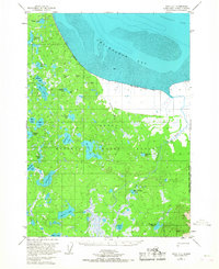
1951 Map of Kenai D-1
USGS Topo · Published 1962About this map
Chickaloon Bay and the tidal reaches of Turnagain Arm dominate this 1950s view of the northern Kenai Peninsula. The landscape is characterized by extensive wetlands and tidal flats, specifically noted as Mud along the coastline where the waters of the bay meet the land. This survey, compiled from aerial photography and earlier hydrographic charts, reveals a nearly untouched wilderness at the mid-century mark.
Find a feature on this map
4 named features on this map. Tap any name to fly to it.
Don’t see what you’re looking for? This feature index may not catch every label — zoom into the map to look around manually.
Map Details
Editions of this 1951 Kenai D-1 Map
2 editions found
Other maps of this area

1944 · Kenai
USGS Topo · 1:250,000

1949 · Tyonek
USGS Topo · 1:250,000

1950 · Kenai
USGS Topo · 1:250,000

1951 · Seward
USGS Topo · 1:250,000

1951 · Anchorage
USGS Topo · 1:250,000

1951 · Tyonek
USGS Topo · 1:250,000

1951 · Kenai C-1
USGS Topo · 1:63,360

1951 · Kenai C-2
USGS Topo · 1:63,360

1951 · Kenai D-2
USGS Topo · 1:63,360

1951 · Tyonek A-2
USGS Topo · 1:63,360