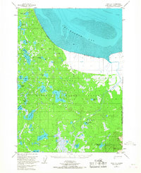
1951 Map of Kenai D-1
USGS Topo · Published 1967About this map
Chickaloon Bay and the silty expanse of Mud define the northern coastline of the Kenai Peninsula in this 1951 topographic study. Inland, the landscape is a complex labyrinth of freshwater lakes and drainage systems within the Kenai National Moose Range. The presence of Trapper Joe Lake and various isolated cabins suggests a region primarily used for subsistence and trapping rather than permanent settlement. The Chickaloon River meanders through the eastern section, feeding into the Turnagain Arm. Names like Moose Pasture Lake, Sportfish Lake, and Bedlam Lake reflect the character of the wilderness, while established paths like the Trail near the river bank provide the only evidence of terrestrial transit across the marshy interior.
Find a feature on this map
33 named features on this map. Tap any name to fly to it.
Don’t see what you’re looking for? This feature index may not catch every label — zoom into the map to look around manually.
Map Details
Editions of this 1951 Kenai D-1 Map
2 editions found
Other maps of this area

1944 · Kenai
USGS Topo · 1:250,000

1949 · Tyonek
USGS Topo · 1:250,000

1950 · Kenai
USGS Topo · 1:250,000

1951 · Seward
USGS Topo · 1:250,000

1951 · Anchorage
USGS Topo · 1:250,000

1951 · Tyonek
USGS Topo · 1:250,000

1951 · Kenai C-1
USGS Topo · 1:63,360

1951 · Kenai C-2
USGS Topo · 1:63,360

1951 · Kenai D-1
USGS Topo · 1:63,360

1951 · Kenai D-2
USGS Topo · 1:63,360