1960s Maps of Kodiak Island, Alaska
Explore 7 historic maps of Kodiak Island from the 1960s. These maps offer a rare glimpse into what life looked like during the 1960s — showing old roads, neighborhoods, homes, and landmarks that have changed or disappeared over time.
Whether you're researching your family's past, planning a metal detecting trip, or studying how Kodiak Island's landscape evolved across the 1960s, these high-resolution maps are a powerful tool for exploring the history of this region.
- Focus on a specific era: All maps on this page are from the 1960s, giving you a focused view of this time period.
- See what’s changed: Compare century-old streets, trails, and buildings to today's modern landscape using overlays and satellite layers.
- Research with precision: Use these maps for genealogy, historical research, land use analysis, or educational projects.
- View, download, or print: Maps are fully viewable online in high resolution, and can be downloaded or printed for your own records.
Start exploring Kodiak Island's history through authentic maps from the 1960s. This is your window into the past.
Kodiak Island, AK maps
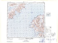
(7)- 1963 Map of Seldovia, 1967 Print
 1963 Seldovia1967 Print · USGSThe lower Kenai Peninsula in the 1960s reveals a rugged coastal frontier where the highway finally meets the sea at Homer. Researchers can trace old settlements and family sites at Happy Valley, Stariski, and the Indian Village near Seldovia.5 unique versions available
 - 1963 Map of Sutwik Island, 1968 Print
 1963 Sutwik Island1968 Print · USGSThe Alaska Peninsula and its offshore islands appear here in the early 1960s, prior to extensive modern development. Map collectors and researchers can trace the remote peaks of the Aleutian Range and the isolated reaches of the Semidi National Wildlife Refuge.2 unique versions available
 - 1963 Map of Sutwik Island A-3, 1968 Print
 1963 Sutwik Island A-31968 Print · USGSThe Semidi Islands are captured in the early 1960s as a remote sanctuary within the Pacific Ocean. Researchers can trace the rugged coastlines of Aghiyuk Island and Chowiet Island along with smaller isles like Suklik Island.2 unique versions available
 - 1963 Map of Ugashik, 1968 Print
 1963 Ugashik1968 Print · USGSThe Alaska Peninsula in the early sixties reveals a wild coastal landscape of volcanic peaks and isolated maritime settlements. Researchers can trace the layout of Pilot Point and Ugashik or locate landmarks like Greig Light and Mount Peulik.3 unique versions available
 - 1964 Map of Mt. Katmai
 1964 Mt. Katmai1964 Print · USGSThe Katmai region in the mid-sixties reveals a landscape shaped by volcanic upheaval and remote wilderness outposts. Researchers can trace the volcanic scars of the Valley of Ten Thousand Smokes or locate remote sites like Katmai Village and Kulik Lodge.
 - 1964 Map of Karluk
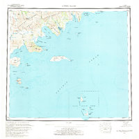
 1964 Karluk1964 Print · USGSKodiak Island and the Alaska Peninsula meet across the Shelikof Strait in the early sixties, a time when commercial fishing and wildlife management defined the region. Researchers can locate remote outposts like the Fish and Wildlife Service Upper Station and the Cannery at Larsen Bay.
 - 1965 Map of Kodiak D-4, 1966 Print
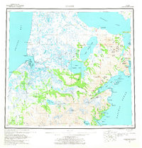
 1965 Kodiak D-41966 Print · USGSKodiak Island and its surrounding straits are captured here in the mid-1960s, showing a landscape defined by maritime industry and protected wilderness. Researchers can trace the coastal layout of the Port Bailey Cannery or locate isolated outposts like the Seaplane Base and various Cabins.
End of results
Showing maps 1-7 of 7
Top cities of Kodiak Island
- Kodiak historical maps
- Old Harbor historical maps
- Port Lions historical maps
- Ouzinkie historical maps
- Akhiok historical maps
- Larsen Bay historical maps
Frequently asked questions
- What are the different types of historical maps available for Kodiak Island?
- What is the oldest map of Kodiak Island?
- Where can I purchase historical maps of Kodiak Island for my home or office?
- Where can I download high-res historical maps of Kodiak Island?
- Are there historical topographic maps available for Kodiak Island?
- Is there historical aerial imagery available for Kodiak Island?
- Where are historical maps of Kodiak Island sourced from?